 Acocks Green History Society
Oxford Road
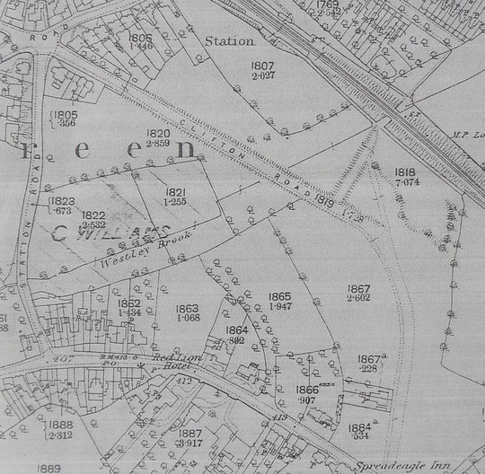
There is an immediate complication when looking at the history of Oxford Road, and that is that the O.S. maps of the 1880s call it Clifton Road, and that some directories call the houses at the Sherbourne Road end Oxford Road, and the houses at the Warwick Road end Clifton Road. This lasts until around 1905. The O.S. map of 1904 has Clifton Road reaching as far as Roberts Road.
Starting with the odd numbers, numbers 1a and 1b are c. 1968, however the earliest buildings are numbers 1 and 3, which were known as Mona Villa and Snaefell Villa, and which appear in a directory of 1876. They have stylish facades, which mark them out from the next row of houses. Number 5 (Beechcroft) appears in a directory of 1892, number 7 (Woodcroft) in the 1891 census, number 9 (probably Eversfield) in the 1891 census, number 11 (probably Broomfield) in a directory of 1892. Numbers 13 (probably Melrose) and 15 (probably Glenroy) date from 1897. Number 3 was a school around 1909, and Eversfield was a collegiate school probably from around 1892 to 1904. A man who won the Victoria Cross posthumously lived at two addresses here: James Neville Marshall.
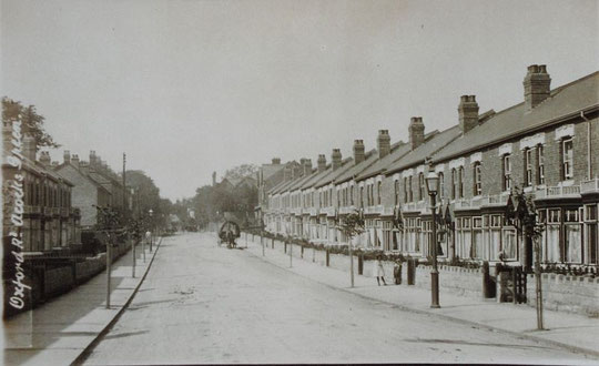
Numbers 17 to 59 are Edwardian. A few named houses appear in the 1907 directory: La Rocque, Swiss Cottage, Rhuddlan, Woodthorpe, Douglas House and Jesmond. Perhaps most of these are in this row. In any event, the rest appear in 1908 or 1909. These are an interesting transitional form of house between earlier designs which taper towards the back and the typical 1920s or 1930s semis. They have a 'waist, i.e. they are narrower in the middle on the outside wall. These houses differ in the gable and bay designs from very similar houses across the road. Number 61 is a 'half-house' tagged on to a normal terrace pair: this different design of house with decorative stonework above the windows continues to number 89. These appear to have been built at the same time or within a year of numbers 17 to 59.
The next house is number 97, dating from the late 1950s. From the early 1940s until about 1956 the Arden Bowling Club was reached through the gap filled by number 97. Numbers 99 to 101, and 103 to 105 are different from the other styles. They are not on the 1904 O.S. map, and may date from a few years later. From here, the houses are the earliest ones listed under Oxford Road. Numbers 107-9 (Osborne Villas) are listed in 1888, 111-13 (Balmoral Villas) in 1888, 115-7 (Ventnor Villas) in the 1891 census, 119-21 (Windsor Villas) in 1890, 123 (Victoria Villa) in the 1891 census, 125 (Paxton House) and 127 (Streetfield) are on the 1888 map, and Streetfield is listed in 1883, so Paxton House is probably of that date too. Number 129 (The Oaks/Oakhurst) is listed in 1883, but may be listed under Louisa Playfair, gunmaker's wife, in the 1881 census. She had her own house, while he was on Sherbourne Road. Two other households are adjacent, so it is possible that numbers 125-7 were already there then.
Number 129 has been replaced by modern flats, and is called Davidson House. It is part of Carrs Lane Homes, now in the hands of Yardley Great Trust, and re-named Carrs Lane Gardens. It dates from 1990. A number of other properties are divided: 1, 13, 125 and 127.
On the even-numbered side, Dennetts furniture shop takes up the frontage from the corner. This is a 1965 extension of the business into their garden on Oxford Road. Since 1937 the business has been run by the Coulles family. Number 2 (Allwyn) and number 4 (Madrescourt) probably date from around 1906. Numbers 6 to 60 are of the transitional design mentioned above, with a kind of 'waist' on the outside walls of the semi pairs. They first appear in the 1909 directory, and one indenture within this sequence dates from June 1908. A track between Woodberry Walk (the original line of Woodcock Lane) and Roberts Road still exists. It is referred to as a party right of way in title documents. The land behind the houses was let in 1913 to house owners for garden or recreation use, and subsequently sold to the house owners in 1920. The right of way had to stay.
Numbers 62 to 136, which also include half a terrace pair in number 100 and 136, appear mainly in 1909 and 1910 directories. They also have the decorative stonework above the windows seen across the road. Numbers 138 (Strathallan) and 140 (Hindley House) are different, and appear on the 1904 O.S. map. Hindley House is mentioned in 1899, so both probably date from a little before then. Numbers 142-4 are semis from c. 1966, and 146-8 appear to date from around 2000.
We would welcome help with the dates above.
It is now possible to see the sequence of large-scale O.S. maps online at www.old-maps.co.uk. For this road enter the postcode B27 6DT, and choose the 1:2,500 maps up until 1952-4 (there is no 1937 map at this scale). Use the plus and minus buttons to change how close up you wish to see the houses. The map can be dragged by using click and hold as normal.