 Acocks Green History Society
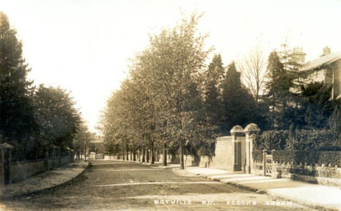
A bit about Botteville Road
Botteville Road is named after Thomas Herrivel Bott. He was born in Brixham in Devon around 1830, was a Church of England Public School Master at the age of 20, and at the age of 30 was living in one of the large houses opposite St. Mary's and describing himself as a Land Proprietor. He moved to Stechford by 1866, where he was listed as a 'Gentleman'. Later he described himself as an author and journalist. He lived until 1904 at Russell House on Frederick Road. Bott was involved through leases in the building of the road, which happened in stages in different styles over several decades. As a Gentleman, he had time to indulge in other interests. For example, in 1882 he had published a 173-page book telling the story of Robinson Crusoe in verse!
The information below is provisional, as it is based on maps, voters' lists and directories, rather than deeds. Any additional refinement of dating would be welcome.
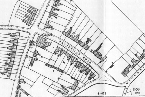
Botteville Road itself did not exist in 1847 at the time of the Tithe Map. However its eventual line is shown by a path.
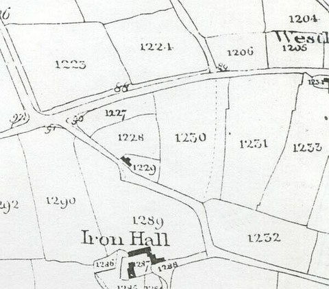
Field number 1230 was called Foot Road Piece, appropriate considering the path through the field, and number 1231 was called Four Acres. Both fields were owned by John Horton, who owned much of the area up to Fox Hollies Road south of Well Lane (Westley Road) and north of March Lane (Greenwood Road, later Olton Boulevard East). The road opposite the beginning of the path is Doge Lane (Hazelwood Road).
John Horton's lands came up for sale in May 1875. Land partly built on and formerly owned by Benjamin Cook, who had died by this time, was also sold at the same auction. Horton and Cook had invested together in land and leases, and Horton was by 1874 the last surviving trustee. The sale catalogue map shows what had been built on Botteville Road by 1875.
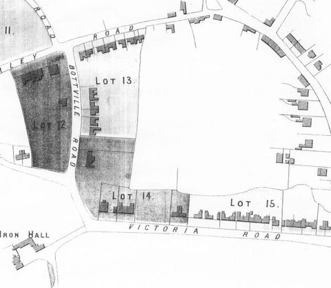
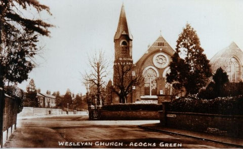
All the lots bore the ground rent date of 29th September 1859, so that is the earliest potential date for any of the buildings. However, it is not easy to prove that any of the buildings were that early. In fact the Methodist chapel/schoolroom is the earliest example we have so far, and that is not on the road itself. It opened in 1863, and is still there, as the right-hand part of the church on Shirley Road. Number 14 (Alton Cottage) dates from 1864, and number 12 (Berne Cottage) from 1867. Numbers 4 (Ross Villa), 6 (Gloucester Villa), 8 (Rose Villa), and 10 (Oxford Villa) were definitely there in 1871. The large house which became the British Legion Club c. 1930 (Beaconsfield/Chalfont) was probably built between 1872 and 1875, and is shown as part of the plot including houses on Victoria Road on the 1875 map. The road is named as Botteville Road (with the 'e') in a directory of 1872. Confusingly, the 1871 and 1881 censuses put some of the houses on Shirley Road or Victoria Road.
On the south side of the road the house shown is number 7 (Poplars in the 1903 directory and the 1911 census). This was occupied from at the latest 1876 until 1900 by Henry Fellows, a silversmith and electro-plate manufacturer. Unlike others on the road, this house was not listed in directories with a house name until after his death. He died in 1900, and his widow Jane continued to own the house, although it was listed unoccupied in the 1901 census and in the 1912 and 1913 Poor Rate surveys. A Mr Derricott was listed there in 1903 and 1906 and a Mr Cooney was listed at the house in 1911. Henry Fellows had a son, Henry Junior, born in 1876, who as an adult lived round the corner in Shirley Road at 1 Gothic Villa (now number 63) in 1876 and later at The Willows (now number 88). Unfortunately, he only outlived his father by two years. From 1934 until about 1950, number 7 was a multi-occupancy dwelling.
The First Edition Ordnance Survey map of 1888 shows an additional structure and grounds to the east of Beaconsfield. The building itself was incorporated into the British Legion club when it was substantially extended in the 1960s.
On the other side of the road, number 1 (Bradenshope in 1884) is in the 1876 directory. It was bought by the Methodist church in 1895 as a manse. The following is an extract from Margaret Bryan's history of the Methodist church:
"On May 10th, 1895, a special Trustees Meeting was called to consider buying the house next door to the church in Bottville Road. It was thought that for the first time Acocks Green chapel should have a manse for the minister. The following advertisement, taken from a local newspaper and dated May 14th, 1895, is stuck into the minute book:
"Messrs. Thomas & Bettridge will sell by auction at the Grand Hotel, Colmore Row, B'ham, at half past six o'clock in the evening:
Lot 3. A well built and comfortable Residence, known as 'Bradenshope', Bottville Road, Acocks Green, containing five bedrooms and box room (readily convertible into bathroom) three reception rooms, 2 pantries, kitchen, scullery and cellar, together with outbuildings and garden and let at a very inadequate rent of £32 p.a. Leasehold for a term having about 85 years remaining unexpired at ground rent of £4 8s 0d."
At this time the church had no projecting chancel and this house stood immediately adjacent to the back of the church. Only a narrow strip of land belonging to the garden of this house, separated the two. According to the 25" to the mile map of the area ‘Bradenshope’ was built on one plot of land with the adjacent plot in Bottville Road being an extension of its own garden. This fact was to be of considerable importance when the school buildings were erected in the early 1930s. A successful bid was made at the auction on 15th May, and the house was bought for the sum of £540. Just four months later the Rev. T.S. Gregory and his wife, took up residence. At the January, 1896 Quarterly Meeting it was announced that the Acocks Green manse had been furnished entirely through donations without any expense to the circuit."
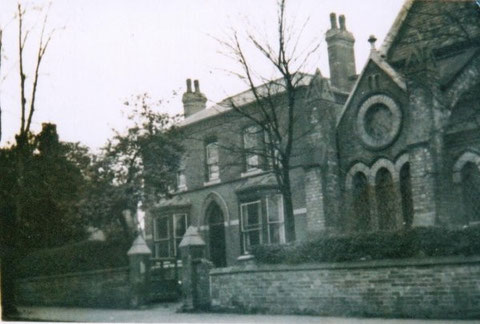
A photo of number 1 is below. The name was changed to Wesley House. Number 5 dates from around
1880. That was later called Ellerslie. There was never a number 3. Both numbers 1 and 5 were demolished and replaced by the church's School and Institute. Margaret Bryan again:
"In May, 1928, the house next to the manse in Botteville Road came up for sale and was offered to the church....The new School and Institute was built on the land formerly occupied by the manse, its adjacent garden and the house acquired by the Trust. To accommodate the minister a house in Sherbourne Road, No.5, became the new manse."
Numbers 9 (Medina Villa in 1880, Hawthornes in 1884, Glenisla in 1901), 11 and 13 (Claremont Villas 1 and 2), 19 (Elms), 21 (Ferndale) and 23 (Hollies) also date from around 1880, as do number 25 (Cedars) and 27 (Woodlands). This has been established from the 1880 directory and the sequence of houses on the 1881 census.
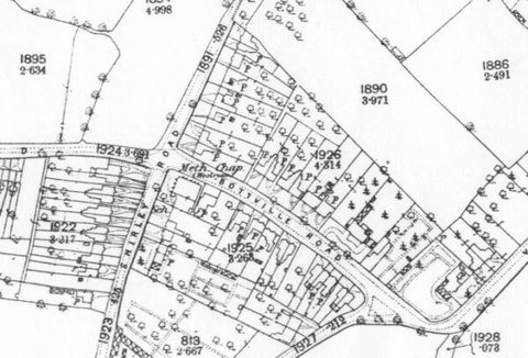
The 1904 Ordnance Survey shows no new buildings on the north side of the road, but a pair on the south side. These are numbers 15 (Greenwood) and 17 (Lyndale). They date from c. 1903. The absence of garden details makes the 1904 map a little easier to interpret. Around 1905 a pair of houses was built to the east of Beaconsfield/Chalfont, numbers 20 (Caversham) and 22 (Westwood House). These occupied the grounds of the long, narrow building shown on the 1888 map.

After World War One one major change was the replacement of the large house on the corner of Victoria Road, whose grounds stretched up into Botteville Road. This was known as Kingswood (Lodge). Dares semis and one detached, were built there, producing numbers 34 - 40, and number 42. Planning permission was granted in July 1934 (and also for other sites at Kilmorie Road and Lulworth Road). The houses were erected by 1935/6.
At the other end of the road, the Methodist church was becoming heavily and successfully involved in social activities and serving the needs of the new council estates. In the mid-1920s it wanted to buy the freehold of the church and the manse, with a view to extension, but discovered that these could not be purchased separately from others on Botteville Road and Shirley Road. The block freeholds were finally bought in July 1932. A year later a new school and institute replaced the manse and the old number 5 (the new manse was to be at 5 Sherbourne Road). There were three large classrooms on the ground floor with cloakroom and kitchen, and a large hall with stage upstairs. No less than 650 children were registered for Sunday school in June 1934, and there were 85 teachers!
During the war, however, the church began to rent out the new buildings, so there was only a brief period when they were able to use the rooms entirely for themselves. Around 1943 the Ministry of Labour and National Service (women's department) moved in, and in 1946/7 Birmingham Council of Social Service joined them. The Ministry of Labour had gone by 1953, but the Birmingham Council of Social Service stayed on. In the late 1960s proceeds from the sale of the church's sports club in Hazelwood Road were invested in the Mersey Docks and Harbour Board, but this proved worthless, and the loss of so much annual interest income meant the school premises had to be re-let to the City. As a result the church itself had to be divided to form a hall and kitchen at one end, and a space for worship with chairs not pews at the other. Margaret P. Bryan's excellent book: A church's story (1986), details these and many other fascinating activities of the church. Sheila Chisholm remembers her family using a way through the back gardens to go down to the church, when she was a young child in the 1950s.
In the 1938 and 1939 directories, Jack Cooper's Botteville School of Dancing was listed at number 9, but after that it moved to 60 Shirley Road.
Mike Wood recalls:
Botteville Road Institute served at one time as an annexe to Acocks Green Junior School, and I attended there for one year in 1959/60. Only two classes of our second year were based there in what
seemed to us an underused enormous cavernous place. The teachers were Mr Worrall and Miss James. The site caretaker was a Mr Hammersley, whose children Royston, Julie and Martin attended our
school. Our headmaster was a Mr Turland, who we called 'Turnip'.
One characteristic Botteville Road shares with a number of roads in Acocks Green is that quite a few of the houses have been in multiple occupancy as bedsits or been divided into flats. During the 1970s half the houses were occupied in this way. This is actually not a recent phenomenon. In 1932 numbers 5, 8 and 13 had more then one family in residence. A year later number 5 had been demolished, and numbers 23, 25 and 27 had also been divided. In 1934 numbers 7 and 12 also became multiple occupancy, and in 1936 numbers 9 and 11 also changed accommodation type. By 1937, however, it appeared that 11, 23 and 27 had reverted, but number 14 was now in multiple occupancy. 1938 saw the first year when number 20 was not single household.
Numbers 4, 6 and 12 were in multi-occupancy in 1945. Number 4 reverted to a single home in the mid-1990s, as did number 6 in 1980. However number 12 has stayed as flats. In 2023 work began on number 12 to add a second gable in the roof at the front, gut and refurbish the interior and build a two-storey rear extension: ten flats for rent will be available. Number 19 was flats between 1947/8 and 1983. Number 17 was in flats from 1955-1976, and number 14 was flats from 1955-1981. In 1959 number 9 was divided up into flats, and it has stayed so. In 1960 number 20 changed to flats, and this is how it has remained. Number 10 was in flats between 1961 and 1978/9. Number 27 was multiple occupancy between 1964 and 1973, when it was bought as a family home, with part use for a decade to house bed and breakfast guests in co-operation with a local hotel. Number 13 was in multiple occupation between 1967 and 1969. Number 15 was divided into flats in 1975, and has remained so. Number 23 was divided into rooms in 2004. Thanks to Sheila Chisholm for help with this information.
New houses have been built on the gardens behind numbers 4-12. The development is called Botteville Gardens. Number 8 has been reduced in width to enable the access road to be built.
These dates cover the last seventy years, and illustrate how some larger houses go through quite long periods where they do not function as single family homes. Use of the voters' lists has required assumptions about occupancy, which may be incorrect in some cases, of course. The road has become more diverse as a result of flats and bedsits, and other interests apart from those of home-owners have naturally made themselves felt. In addition the presence of the former School and Institute buildings and the British Legion club also provided function and ambience that was non-residential. The School and Institute were used by the city as a Neighbourhood Office until 2010. In 2016 work began to convert the building into apartments. The old British Legion building, which included ugly modern extensions, was demolished in 2016 and a pleasant new building in keeping with its Victorian neighbours now occupies the left-hand part of the site. To the right houses are being built, called Bowling Green Mews.
It is now possible to see the sequence of large-scale O.S. maps online at www.old-maps.co.uk. For this road enter the postcode B27 7YE, and choose the 1:2,500 maps up until 1952-4 (there is no 1937 map at this scale). Use the plus and minus buttons to change how close up you wish to see the houses. The map can be dragged by using click and hold as normal.
The Watson family in Acocks Green