Acocks Green History Society
Acocks Green and all around, section three
Education
From at latest the 14th century a school had been in use beside Yardley Church. The building so fortunately preserved is of 15th century half-timber framing and 18th century brick. Legacies to the Yardley Great Trust for poor relief and education had made it wealthy enough to permit the opening of a second school, known as the Hall Green Charity School, on the Stratford Road/School Road corner. It lasted from 1721 until 1899. Boys only were educated there, largely by members of the long-lived Swinburne family. A girls' school nearby in 1835 did not long survive.
For nearly thirty years Horsfall's little school educated children of wire-workers at Hay Mill. In 1874 St. Mary's Church School opened in Fox Green Lane. For twenty-six years from 1858 the Rushall Lane chapel was in use as a Nonconformist school. Yardley School was set up following the 1870 Act, but it did no more for the first twenty years of its existence than help to support existing sectarian schools, despite the huge increase in child population for which those could not provide places. Then the old Stockfield Road chapel, and rooms in Bard Street Sparkhill were in use as Board Schools until Greet and Redhill Board Schools were ready to admit the hundreds of illiterate children of Greet and Hay Mills (1892). The Board met thenceforward in a building on Warwick Road, now the caretaker's house, next to Greet School, which had been built on the site of Greet Farm.
In 1902 Worcestershire Education Committee succeeded the Yardley Board. It opened a temporary school in an iron building near Broadyates House in 1906, and closed it two years later when Church Road Schools were completed.
Formans Road School opened in 1907, and the Acocks Green Schools two years later. Holy Souls R.C. School had by then been open for two years. St. Mary's School in Broad Road, condemned in 1906, was saved by renovations during the next few years: it finally closed in 1974.
In 1904 the County had established Yardley Secondary School in Sparkhill Institute, vacated by the Rural District Council on completion of the new Council House. Six years later the school moved to the recently vacated site on Warwick Road, overlooking the new engine sheds and sidings. Youthful detractors called it 'Tyseley Tech'. However, it was centrally placed to provide secondary education for boys and girls from all over Yardley, though some had a four-mile journey on foot or bicycle to reach it. Golden Hillock Schools opened in the same year, 1910. The English Martyrs School Sparkhill, of the following year, was the last to be built pre-World War One hereabout. Birmingham Education Committee, which took over in 1912, needed to build no new schools until the late 1920s, when the new municipal estates were producing large numbers of children. For them were provided Yarnfield (1928), Hartfield Crescent and Oaklands, Dolphin Lane (1929), Severne and Pitmaston (1931), Cottesbrook, Yardley Road (1933) and Lakey Lane (1935) and Yorkmead, York Road (1937).
English Martyrs School was destroyed by bombing in 1940 and its replacement was begun ten years later. A demolished wing of Yardley Secondary School was replaced in 1953 by one of three storeys whose windowless front wall carries a large carving of the school badge: the pears of Worcester are prominent thereon. Gilbertstone School opened in 1950 and Archbishop Ilsley R.C. Secondary seven years later on an enclosed site between Victoria and Shirley Roads. Cottesbrook and Holy Souls have moved to new premises, St. Christopher's R.C. School opened in the 1960s off Shirley Road and is now called St. Ambrose Barlow, the Harrison Barrow/Hartfield Crescent schools combined as a comprehensive in the 1970s.
Public transport
Canal flyboats continued to serve the needs of Yardleians travelling to Birmingham or Warwick until the mid-19th century. Turnpike improvements, notably those of Telford on the Coventry Road c. 1815, had brought fast, regular, and punctual stage-coach services. In 1847 construction of the Oxford to Birmingham Railway began. Crossing the Rea valley by a great blue-brick viaduct, its tracks were at ground level across Small Heath and the Golden Hillock above Danford. The Warwick Canal was spanned by a high iron bridge, then Spark, Cole, and Hay Mill head-race by earthen bank and brick culverts. A deep cut had to be made through Tyseley Hill, Stockfield, and Crabtree Field: five bridges, high narrow structures of local brick, were built to maintain rights of way. Yardley Road was raisod to take it over the lines. Rowe Leasowe Lane went under the bank made for the crossing of Kineton Green Brook. The first station after Snow Hill and Bordesley was 'Acocks Green & South Yardley', opened with the line in 1852: this was probably the first use of the misnomer. Yardleians could now travel in a few minutes right to the centre of Birmingham, and the future of Acocks Green as a commuter suburb was ensured.
Counties having largely taken over road maintenance, tollgates were no longer manned, and horse-buses could ply without payment along the former turnpikes. They came from 'town' to Sparkhill and the Swan and the Spread Eagle. By 1885 Company steam tramcars had reached as far as the Cole on Stratford Road, and Victoria Park on Coventry Road: after the toll bridge at Hay Mill had been replaced in 1903 tracks were laid up Red Hill, and they had reached the Swan a year later - not only tracks but overhead cables too. Electric-powered cars replaced the hated steamers as soon as a generator station had been built near the terminus (the former Colliers site). Within Birmingham the lines belonged to the Corporation, and the various Companies' rolling stock was acquired as their leases expired. The lines through Yardley were bought after the Rural District joined the City, so that all public transport was thenceforward owned and operated municipally.
The humped bridges at Greet Mill on Stratford Road were replaced by one over a new central channel in 1913, and the following year tramcars reached Hall Green. The tracks moved on to the boundary at Shirley in 1928, being from Four Ways (Fox Hollies Road/Highfield Road junction) placed on a central reservation between two carriageways. Warwick Road required so much widening, straightening, raising, draining, and rebridging before tramlines could be laid that the work was still in progress during World War One. Along the narrowest part of the road through Greet, only a single track could be laid: it was controlled by red and green lights at either end, probably the first traffic lights to be installed on a city road. By 1916 the lines had reached Broad Road, and no further work was done for six years. Then the tracks were extended to the Shirley Road junction: because of the narrowness of Warwick Road therefrom trams never reached the City boundary hereabout, the terminus being made on the junction green just beyond the culverted Westley Brook.
Meanwhile there had been railway development which was drastically to alter the appearance of Hay Hall, Stockfield, and Tyseley farmlands, not only by its own works but in what it brought. In 1906 the Great Western Railway, successor to the Oxford Company, began construction of a line to Stratford. This line, which was intended to bring the dairy produce of Arden speedily to the ever-growing city, had been planned by another company some years earlier, but there was nowhere that the line could be thrust through the inner suburbs without much demolition of property. The G.W.R already had such a line in use and now planned to use it, suitably widened, as far as Tyseley Hill: thence a new line would cut through the hill, curving between Tyseley Farm and the terraces of Acocks Green, continuing south through Hall Green and Yardley Wood. By late 1907 the line was in use, its many stations including those below Stratford and Highfield Roads. A junction station was built at Tyseley, and in the meadows of Manor House Farm sidings and engine sheds were built, Tyseley Brook being diverted to accommodate them. Wharves were provided below Tyseley Grange, and beside Kings Road. In Birmingham a second viaduct paralleled the first, and a new terminus was built on the site of the old Public Offices in Moor Street. Many extra tracks were laid across Small Heath, the cutting through Crabtree Field was greatly widened, and Acocks Green Station was rebuilt in 1907.
Sheldon was added to Birmingham in 1931, and public transport was needed to the new boundary two miles east of the Swan. Trams were now out of favour, because they held up other traffic, notably in Bordesley, so in 1933 electric-powered trolley-buses replaced them along the entire Coventry Road route. A layby was made on the site of Heybarnes Farm close to Hay Mill bridge.
After World War One the City had been able to give attention to the task of linking the large peripheral areas of suburb and farmland acquired in 19l1-12. There was difficulty even in choosing which narrow lanes to use for the intended circular routes, and the provision of tramlines could not even be considered.
When in c. 1923 the first suburb-joining motor-bus service, between Acocks Green and the City centre via Edgbaston, Moseley, and Springfield was started, the Yardley part of the route, perticularly Shaftmoor Lane, was in urgent need of tarmacadamising, draining, kerbing, and lighting. It was not until 1926 that the route chosen for the Outer Circle 11A service was considered to be adequate. This had perforce to go through all the centres of population and shopping: neither on Stratford or Warwick Road was a direct crossing possible. Plans for a dual carriageway along the whole route, and for a ringway which would enable traffic to avoid the worst areas of congestion were being carried out slowly from the late 1920s, and were advanced during the Depression when roadworks provided employment. Thus in our area, Highfield, Fox Hollies, and Stockfield Roads were widened in part, while Stratford and Coventry Roads became highways worthy of a huge city here and there. Another far-sighted scheme to bypass Acocks Green was the making of Olton Boulevard from the Cole to the boundary at Olton via Fox Hollies. All these works were abandoned in 1939. The Stockfield and Yardley Road bridges were completed in good time, but not the Spring Road railway bridge needed for this scheme, and the Boulevard is not even begun between Greet Inn and Reddings Lane.
Since the war public transport has been the victim of private transport: the economical tramcar has given place to the diesel motorbus on all routes, but this both suffers from and helps to cause the increasing congestion of traffic. Hugely expensive works like the Swan underpass and the Coventry Expressway make ever less likely the completion of inter-war plans for easement of traffic flow through Yardley.
Later industry
It was inevitable that industry would develop on the Hay Hall Estate after World War One. It lay between canal and railway, with loading facilities on both, and there were already six factories along the Kings Road axis. There was a labour force in the terraces of Hay Mills and Acocks Green and the newish suburbs on Greet Hill, and trains and trams to bring more from the city. By the later 1930s a complex of more than fifty firms occupied practically the whole area enclosed by the canal, the railway, and Stockfield Road. Though some were large concerns such as Rover, Girling, King Dick, Slumberland, Bakelite, Excelsior, C.W.S., Smiths Crisps, and Wilmot Breeden, there were also many light engineering works covering only a half or quarter acre. The Hall itself survived, on the premises of Reynolds Tubes.
Other areas of industry were the West Greet concentration (Serck, Brooke Tool, James Cycles, Tangye), Tyseley Hill, the Formans Road/Weston Lane/Reddings Lane/Olton Boulevard grouping (Lucas, M.E.M., etc.), and the North Warwickshire line between Shaftmoor and Hall Green.
The Second World War and the growth of motor-vehicle component industries brought enormous development of Lucas's (Formans Road, Spring Road, Shaftmoor Lane) and Wilmot Breeden (Amington Road, Kings Road). A newcomer, Harmo Industries, became one or the largest concerns on the Hay Hall Estate. The wrongly-named Tyseley Industrial Estate of a score of small factories occupied the Wilders site off Warwick Road, between brook and river, hampered by its narrow single access, Seeleys Road.
Urbanisation to 1900
At the start of the 20th century most of Greet Quarter was shared by a few large farms. These were Moat and Highfield Farms on Coventry Road, Lyndon Farm on the boundary, Hay Hall, Waterloo, Stockfield, and Greet Manor Farms. Built-up areas were clearly defined. Long terraces of tunnel-back houses were new-built or in building at Spark Green, West Greet, Tyseley Hill, Stockfield Road south end, and Mansfield Road. There were eight streets, largely complete, in the industrial village of Hay Mills. On Yardley Road south of the canal there were mansions in large gardens, and the cul-de-sacs down to the canal were partly developed. Warwick Road was built up as a residential street from Westley Brook almost to Clifton (Oxford) Road. Arden, Flint Green, and Sherbourne Roads were on the way to completion, as was Station Road. Streets laid out but little or not at all developed were Alexander, Greswolde Park and Dudley Park Roads, while The Avenue was built up only on the railway side.
The land-use divisions of Broomhall Quarter in 1900 were no less marked. Sparkhill's terraced streets occupied the wedge between the two main roads. Development at Acocks Green was confined within Fox Hollies, Greenwood, and Victoria Roads. Only Westfield and Botteville Roads were practically complete, other streets having long rows of houses on one side only - thus Victoria, Greenwood, Hazelwood, Shirley, and Broad Roads. Notable of the pattern, which was largely that of doveloping old lanes, was the great amount of land enclosed between these, to be used for nurseries and in recent times providing sites for schools or 'town house' estates on cul-de-sacs. Elsewhere in Broomhall there were only three tiny hamets - East Greet opposite the Manor Farm, Tyseley Hill by the Britannia Inn, and 'The Hamlet' at Hall Green, a scatter of handsome houses built by the Severnes in the 1880s and 1890s. Otherwise, the whole Quarter was parcelled out among a score of mansions, a few inns, and thirteen farms - Greet Mill Hill, Shaftmoor, Tyseley, Fox Hollies, Hiron, Hall Green and Broom Hall, Redstone, Pool, Fox Green, Sandpits, Gospel House and Robin Hood Farms. There were shops for local needs, most of them in converted houses, on the main roads, and the start of shopping centres at West Greet and Acocks Green, at Spark Green, on Sparkhill, and at the Swan.
Yardley into Birmingham
The ever-faster growth of building and population in what was still so largely a rural district strained the quite inadequate administrative machine and its provision of services. Yardley lacked most of the necessities of urban life - road surfaces, drains, and lighting, baths, pure water, refuse collection, hospitals, libraries, inter-district transport. Birmingham water reached Acocks Green in 1890, and thirteen years later there were new mains to the 'town' of Sparkhill. Gas from the City also became available to the new housing areas. The Rural District Council received much help from Worcestershire, which feared the loss of Yardley to Birmingham. The county provided the new Council House on Stratford Road, in 1902, and police stations at Hay Mills and Yardley Road. (Until then Acocks Green's police and firemen had shared the house in Warwick Road opposite Dudley Park Road). The Rural District Council bought the Yardley/Solihull Fever Hospital at Lyndon End in 1909, spent a lot of money on main roads and bridges, and planned for the future: the sewage farm at Deep More, all too close to new houses and incapable of enlargement, was to be closed and a new sewer laid to the Cole Hall sewage works, and Yardley was to be developed on Garden City lines, with the Cole and some tributaries as green ribbons of meadowland, but all was to no avail. The new Yardleians were mostly Brummies, and they voted to rejoin the City, which promised them the best of services and amenities.
When the First World War began, a start had been made on the immense task of road improvement and lighting, and of mains-laying. The bridges over the Cole on Stratford and Formans Roads were replaced (1912-13), and the canal bridge over Kings Road (1913). An electricity generating station was built in Evelyn Road, Sparkhill. Other construction work tailed off only gradually during the first two years of the War, and resumed as materials became available after it. In 1918 the South Birmingham Town Planning Scheme was published: it accepted the plan for the Cole and other valleys, proposed the zoning of industry separate from housing, new highways and improved old ones, preservation of trees, grass verges, and development at a maximum of twelve houses to the acre. In Yardley there were six thousand acres to be developed. Acocks Green got a new fire station behind the police station on Alexander Road c. 1923.
The marked lack of north-south roads through the former Rural District was to be remedied by four schemes. Highfield/Fox Hollies/Stockfield Roads were to become dual carriageways one hundred and twenty feet wide, with a central reservation of grass and trees: a new short road was to link Fox Hollies and Stockfield Roads directly across Warwick Road. Woodcock and Clay Lanes were to be widened as part of a highway from Shirley Road via Dolphin Lane to Coventry Road. A completely new route was planned to link Stratford and Warwick Roads, from Cateswell Road to Tyseley Hill: and another was to make good the lack of a riverside highway, linking Sarehole and Bromyard Roads to roads north from Titterford and south from East Greet, where there would be a junction with an east-west highway designed to bypass Tyseley and Acocks Green. Cateswell/Tynedale Road is long since complete, but the other schemes have not progressed since 1939, with the exception that some work looks imminent at Stockfield Road. The riverside route stops at Formans Road.
Amenities
Yardley Rural District Council had first leased and then bought (1898) Broom Furlong from the Charity Trust for use as a cemetery. The Trust had given several pieces of land to the Council for public open spaces, but of these only one (Sparkhill Park, 1904) had been opened when they passed to Birmingham. The others were brought into use, and other pieces acquired, during the next two decades. Among the former were Formans Road and Fox Green Recreation Grounds: the latter included Fox Hollies Park and schools playing fields at Tibbotts Green (off Shirley Road) and Oakhurst, north of Broom Hall. A tiny addition to these was Wynford Road Recreation Ground, a fragment of Nether Heyne Field. The river plan was carried out in Swanshurst and Church End Quarters before public access between Stratford and Warwick Roads was finally made in the 1980s. Allotments were always a feature of rural Yardley, and there used to be were eighteen patches in the central Quarters, the largest being at Deep More and between Formans Road and Weston Lane.
Public Baths were opened on Sparkhill in 1931. The Council House was already in use as a library, and in the 1930s new library buildings were erected at Acocks Green and 'South Yardley'. They were both set back on building lines which permitted road-widening : enlargement of the Green about the tram terminus began in 1929 with cottage demolitions. Similar work in preparation for the widening of Yardley Road had swept away Rose Cottage and others. There had been few purpose-built shop rows before Hall Green Parade, 1913, and conversions of villas and terraces have continued to the present. Rebuilding of older premises was less common than wholly new rows and new centres, notably that at Fox Hollies. Old inns were rebuilt or re-furbished - the Dolphin (replaced by Aldi 1991), the third Swan (replaced by offices in the 1990s), Waggon & Horses, Horseshoes - while along the tram and bus routes and at their termini palatial pubs appeared. The two New Inns, the Gospel Oak, Good Companions (demolished in the 1990s), and Robin Hood are examples. In the late 1930s there were seven cinemas hereabout - Piccadilly, Springfield, Rialto, Robin Hood, all on Stratford Road, the Tyseley and Warwick, and the Adelphi on Red Hill. By then several new bus services had been provided - 31, 3lA, 32, and 36 - for the council house estates, and both tram routes had been taken over by buses: those on Warwick Road travelled to the Olton boundary. A halt had been made at Spring Road on the North Warwickshire Line in 19l9. A large bus depot was built at Fox Green.
Refuse disposal locally was by dumping and burning at the boundaries hereabout until the Destructor was built in James Road: its concrete bridge over the canal replaced the humped brick arch leading to Hay Hall Cottage and the mill. Deposits of clinker in the meadows north of the canal, and between it and the railway have raised the level to that of the embankments, so that now the brook, river, and head-race lie deep in spectacular gorges.
Inter-war housing
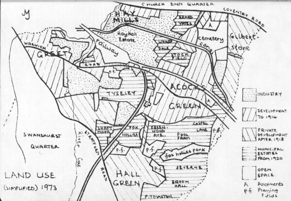
This subject has been dealt with in some detail in my Urbanisation of Yardley, to be found elsewhere in the Acocks Green History Society site. Broadyates, started in 1924, was one of the earlier estates, and for the next seven years there was great municipal activity in the two Quarters. The Waterloo, Manor Farm, Tyseley, Shaftmoor, Fox Hollies/Pool Farm, Stockfield, The Avenue, and Pitmaston Estates were all built during this period. The municipal streets are characterised by their geometrical patterns, which produce some very odd-shaped gardens, contrasting with the straight or gently-curved streets of private developers. One might generalise that on council estates the houses are plain and the roads are fancy, while the reverse is true of private ones. While the typical be-mortgaged house is the 'semi', a council house may be in a group of any number from two to six. The distribution of both kinds of development is shown on the accompanying map. Only one small estate of the post-Depression activity of the Council is to be seen hereabout, Hilderstone, but speculative development continued spasmodically until 1939.
Post-war, today and tomorrow
The Warwick Canal, part of the Grand Union after 1929, had been improved by bank shoring and the widening of the Yardley Road tunnel, just in time for its wartime commercial use: since then the wharves and loading bays of Hay Hall Estate are derelict, and only pleasure craft use the waterway. The railways have struggled too, with dingy stations, and the great expanse at Tyseley is largely occupied by the Railway Museum. The North Warwickshire Line has been under sentence of closure. Perhaps rail travel locally will have a renaissance, now that the improved roads made between the Wars have finally become choked with traffic. Motor buses replaced trolleys on Coventry Road in the late 1950s. Bus competition has introduced some ancient and strange looking vehicles onto existing and new, speculative routes. The car and the lorry continue to usurp the functions of bus and train despite the inadequacy of the roads.
Historic buildings are ever fewer. Hay Hall, Pinfold House, Rushall Lane Chapel, and the Arden Road cottages are all we have left. Acocks Green House, Broom Hall, Tyseley Grange, Stockfield Hall, Field Gate Farm, cottages on the corner of Flint Green Road and Muscott's Tannery have been lost. Even modern buildings are not safe: the Rialto and Robin Hood cinemas have been replaced by supermarkets, though one cannot mourn their loss as buildings. The Dolphin was replaced by a supermarket in 1991, and the Fox Hollies went the same say a decade later, with only the fine Fox and Hollies emblem remaining in the wall of the new building. Crosby Hall School (the former Convent School) was replaced by a supermarket ten years before the Dolphin. Hall Green Little Theatre is a gain, if not architecturally .The third Swan ('Europe's largest') has gone. Yardley's extractive industry has ended. The Burbury pit is level ground, filled with industrial waste much more quickly than it was excavated, and the Waterloo brickworks pit was abandoned. The greatest excavation of recent years locally was that which put Tyseley Brook completely underground, in what is called the Hall Green Valley Sewer.
Shopping areas have flourished generally, although Greet is dying. Acocks Green has developed notably from Station Road to Oxford Road. However, the Co-op supermarket retreated from its early 1960s row to the Green, and then abandoned that site, finally re-appearing in 2004 across the island at Shirley Road in much smaller premises. Part of the former Co-op premises in the 1960s block are now a pub, given the historic local name of the 'Spread Eagle', and containing local history photographs and information.
Despite a service road and a short stretch of dual carrageway, parking is a great problem, as on Sparkhill, at Springfield, and to a lesser extent at Hall Green. Warwick Road at the Green is still narrow. Housing development has not been spectacular, except at Fox Hollies, where towers rise in the former hall grounds. New estates, both municipal and private, have generally been small, being infillers of those conveniently-left spaces, and cramped to an extent that would have horrified the Rural District Councillors of 1909. As available sites become fewer, there is more demolition of Victorian mansions, and their replacement by terraces and slabs of flats. Two system-built areas of housing, at Stockfield and Gospel Lane, have had to be demolished and replaced. Conservative legislation encouraged municipal tenants to buy their homes, and as many as a half of the houses on some estates are now privately owned, with some householders struggling to keep their houses maintained.
These must surely be typical features of the future hereabout, and one wonders how long the open spaces will be safe. Reduced mobility due to the cost of petrol and the sheer misery of driving in the City for more and more of the day might bring them back into greater public use - just as it may give a new lease of life to the railways and even the canal. Coventry Road has certainly become the Eastern Expressway, if not a dangerous race-track, but flow of traffic along Stratford Road is not being achieved by widening but by designation as a so-called 'Red Route', where no stopping is allowed. Meanwhile the only relief on the Warwick Road in Acocks Green is an attempt to improve the staggered junction at Fox Hollies and Stockfield Roads. There is a short widened stretch at Greet, however, where traffic takes advantage of the ability to travel faster!