 Acocks Green History Society
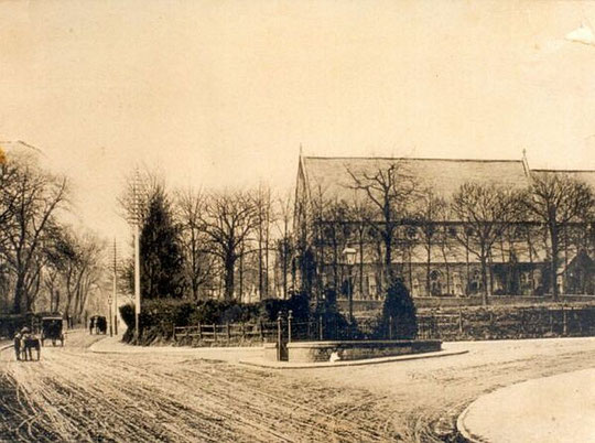
Dudley Park Road
Dudley Park Road is unusual in several ways. It is not an old lane, but a new road cut in the last quarter of the nineteenth century. The name Dudley Park has provoked interest, and local deeds establish that the name results from purchase of the land by William Dudley, a well-known Birmingham jeweller. This was put into a deed poll for the benefit of his heirs, and after William's death in 1876, his son and other trustees began to develop the area. One of the trustees was Joseph Wilson, gunmaker and one of the founders of the B.S.A., who lived on Yardley Road. However, curiously, building did not start from the main road but from the junction of roads which became known as Acocks Green's own Five Ways. In a sense, this is understandable, because much of the building of large houses near to the new railway station of 1852 was focused around Sherbourne Road. One of the first houses to be built was known as Dudley Lodge (later 57 Station Road/Teall House), on the left at the junction with Station Road. In 1879, across the road at the junction with Sherbourne Road, the Acocks Green Institute was built, a high-class social and educational establishment. More detailed information about the Institute is on the page about Sherbourne Road. So this was meant to be a sophisticated, posh road. Why Dudley Park rather than just Dudley? Maybe it was to avoid an association with the grimy Black Country town of the same name! A small number of houses was built from Five Ways between around 1876 and 1890, and 'parkland' remained beyond these few residences as far as the Warwick Road until the mid-1920s.
The 1880 directory lists Fairfield, but also two other houses, which are actually on Station Road (including Dudley Lodge), but with gardens running west to Dudley Park Road. In the 1884 directory are also listed Avonmore and Churchfield and a ladies' college. The land for the Public Hall /Acocks Green Institute was Dudley Land. The 1891 census lists Fairfield, Churchfield, Avonmore, Avondale, Jesmond House, Victoria House, and two unnamed properties occupied by Henry Martin and Walter Waters. Henry Martin's wife is listed as a schoolmistress, so the house may have been used as a school. The 1888 O.S. map shows four houses on the west side and the Institute, so it would appear that the four houses on the right-hand side (two pairs of semis) were built between 1888 and 1891. Naming of the houses in the directories was from the south to the north, although there appear to be inconsistencies in the order at times. When numbering was introduced c. 1915, however, it ran north to south. Unravelling this has proved difficult, and we may not have got it right! To add to the complications of understanding this short road, the numbering which was brought in c. 1915 was changed on the west side c. 1938.
On the west side, between 1884 and 1901 Avonmore, Churchfield, and Fairfield retained their names, although Fairfield was called Fairview in the 1892 directory. Avondale may have become known as Stantor by 1897. A fifth house, north of the other four and on part of the grounds of the Institute, is listed in the 1901 census as Tracey. Tracey became Singleton by 1910. The conclusion we have reached is that Tracey was number 4, later 16; Fairfield was 6, later 20; Churchfield was 8, later 24; Avonmore was 10, later 28, and Avondale/Stantor was 12, later 32. In the 1923 directory houses numbered 14, 16 and 18 appeared, but these were re-numbered as 18, 20 and 22 in 1925 (later 38, 40 and 42). The number 16 re-appeared for Tracey (4) after this, but the original 16 became 36 later. Number 14 (later 34) appeared in the 1930-1 voters' list. This has been the St. Mary's vicarage since the mid-1970s. Numbers 26 and 28 (46 and 48) appeared as Penjerrick and Jesmond Dene in the 1924 directory, and number 24 (44) appeared in the 1925 directory and voters' list, along with 30-38 (50-58).
On the east side, the new houses appear to be Jesmond House/Jesmond Dene, Victoria House, Montrose Villa, and Ormond House. In 1899 the sequence was Austerlands, Montrose Villa, Victoria House, and Hazeldene. By the 1901 census, Victoria House had become known as Bron-Prys. Hazeldene changed its name to Fonthill by 1903. Austerlands changed its name to Parkfields by 1907. Bron-Prys was not listed in 1910 and appears to have become Southill, while Fonthill was not listed in 1911, but Woodstock appeared in 1912. A new house appeared in the 1913 directory, south of the two pairs of semis, called Wuthrums. The conclusion we have reached is that Hazeldene was number 1, Victoria House was number 3, Montrose Villa 5, and Austerlands 7. Wuthrums is number 9, there is no doubt about that.
Number 11, a detached bungalow, appeared in the 1923 directory as Nairne, and the detached house number 13 (now 11a) appeared by 1925, along with the sequence of semis going down towards the Warwick Road, numbers 15 to 41. This resulted from sale of land south of Stantor and Wuthrums to Charles Hougham, builder, in 1923, and the mixture of detached, large semis and smaller semis followed by 1925 on both sides of the road.
Around 1938, the remaining grounds of the Institute were covered with detached houses on Sherbourne and Dudley Park Roads. This necessitated re-numbering of the west side. The three new houses on Dudley Park Road became 8, 10 and 12. Number 4 became 16. This is Dudley Court Rest Home. Number 6 became 20 (Fairfield). Number 8 became 24, 10 became 28, and all the numbers from 12 onwards had twenty added on, so 12 became 32, and so on.
Since the war, there have been many changes, and the west side has seen most of these. Bill Simpson, Doctor Finlay from the TV series, lived at number 16 from c. 1947 to c. 1954. Number 16 then became a dance studio, the Starlite School of Dancing, from c. 1954 to c. 1960. In 1973 it was converted into 6 flats, then became a rest home in 1977. In 1984 the home took over numbers 1 and 3 across the road, but these became flats in 1997. Next to number 1, the Carrs Lane Trust built across the gardens of 51 Station Road after demolishing that house, creating 1a Dudley Park Road. Number 20, always known as Fairfield, became 'the first municipal home in the country for deaf and blind people' in 1952, after wartime use as a hostel. In 1973 it became a childrens home, and was demolished c. 2010, with the institution itself having moved to Erdington in 2004. See the Connecting Histories website for more information. The site is adjacent to the large Christadelphian Homes complex on and behind Sherbourne Road, and may become part of it in the future. Number 24 was listed as a nursing home from 1941 to 1950. A midwife lived there before and after. This house, known previously as Churchfield, was demolished and replaced by Sharon Court flats in 1974. Number 28, Avonmore, was occupied by a doctors' surgery in 1988 and demolished and replaced two years later. Number 32, Stantor, remains standing.
With houses as large as those built before 1900, it was
likely they would be occupied by more than one family as the twentieth century progressed. For example, the 1930-1 voters' list has 3 surnames at number 1, and 3 at number 12. By 1935, number 1
had been divided into 1 and 1a (not the same as the later Carrs Lane 1a, a separate building), with 1 having 4 surnames, and 12 having 5. By 1945, number 1 had 5 surnames, 1a had 3, 7 had 3, and
24 (the old number 8) had 4 surnames. By 1950, number 32 had 5 surnames. By 1955, number 5 had 4 surnames, number 32 had 2, number 28 had 2, and number 24 had 5. This was most probably
functioning as a care home. Number 20 was a home for blind and deaf women, and number was 16 in 2 flats. Number 24 had 7 surnames in 1960, and in 1965 number 1 had 4 surnames, number 3 had 6,
number 5 had 2, number 32 had 4, number 24 had 7, and number 16 had 5 surnames. Number 7 was in 5 flats in 1973. It would appear that this picture was a result of a mixture of lodgers' rooms,
care facilities and flats over time.


It is now possible to see the sequence of large-scale O.S. maps online at www.old-maps.co.uk. For this road enter the postcode B27 6QP, and choose the 1:2,500 maps up until 1952-4 (there is no 1937 map at this scale. Use the plus and minus buttons to change how close up you wish to see the houses. The map can be dragged by using click and hold as normal.