 Acocks Green History Society
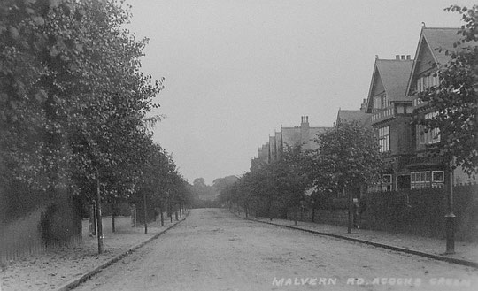
Malvern Road
Malvern Road was built up for the most part between 1895 and 1915 on land formerly part of the Malvern Hall Estate, sold by the Greswolde-Williams family.
Number 1 (Lyndwood) is listed in the 1901 census, as is number 3 (Harleston House/Ellerslie). Number 5 (Strathmore) is in a directory of 1912. Numbers 7-11 were built in 1960. Number 15 (The Hollies) was listed in the 1901 census, but number 17 (Malvern House) is in a directory from 1896, and presumably number 19 (Penshurst, also in the 1901 census) is of the same date as number 15. The flats at number 25 date from 1965. The 1916 O.S. map shows a gravel pit there. Number 27 (Richmond Villa) is listed in 1901, but number 29 (Brunswick Villa) is listed in a directory of 1896, so the earlier date probably applies to both. Number 31 dates from 1932. Numbers 35 (Brooklands), 37 (Prenton), 39 (Rozel), 41 (Bromfield), 43 (Hornsey/Caer Glowe) and 45 (Homeville) are not on the 1904 O.S. map and were built from 1906 (Ann Clarke). They are all in a 1908 directory. They are now locally listed. Number 47 dates from 1991.
Number 2 (Roseleigh) is listed in the 1901 census. Numbers 4,6, and 8 were built in 1960. Number 10 (?Fairholme) and number 12 (Grasmere/Heathmere) were also listed in 1901, as were numbers 14 (Hazelhurst) and 16 (Lyndhurst). Numbers 18-34A belong to the Colwall Walk development of 1962. Acocks Green Tennis Ground was at this point in the road in a directory of 1921. Number 34 B appeared in 1966. Number 36 (St. Hilary's) was listed in a directory of 1912, number 38 (Bradda) in 1913, and numbers 40, 42, 44 and 46 in 1915. Numbers 48 and 50 date from 1938.
A number of the houses have been and a few are divided into flats.
It is now possible to see the sequence of large-scale O.S. maps online at www.old-maps.co.uk. For this road enter the postcode B27 6EH, and choose the 1:2,500 maps up until 1952-4 (there is no 1937 map at this scale). Use the plus and minus buttons to change how close up you wish to see the houses. The map can be dragged by using click and hold as normal.