 Acocks Green History Society
Ancient roads
The first roads in this unattractive region of forest, swamp, and stony heath, were not important routes for human movement but purely local tracks going only as far as their makers needed them. The first to tread the ridgeways and terrace tracks were animals, and men followed them - first to hunt and later to settle. These ways were not 'made' in any modern sense: after the Romans there were no road-builders but only road-menders in Britain until the Turnpike Trusts. Trodden routes became fixed if they served a purpose, but were never planned. They took the easiest way, which meant avoiding woods, bogs, streams, and steep slopes wherever possible. Their linking-up to form a system of communication with other manors was a slow process related solely to need: the concept of regional or national highways did not emerge until medieval times.
The old roads of Yardley were clearly influenced by geology and drainage. It is notable that there are few ancient riverside roads, because the clay and alluvium made too hard and heavy going
except in driest weather. The exceptions are Priory Road in Yardley Wood, the bottom stretch of Wake Green Road, and the two Stoney Lanes, all of which are on gravel. Beyond Titterford the main
route through Yardley climbs to Highfield on boulder clay, and stays thereon, following the dorsal ridge-top between the Tyseley and Broomhall Brooks (Fox Hollies Road). It is possible that the
original track continued via Broad Road, Flint Green Road, and Dalston Road, which occupy the crest, rather than along Stockfield Road: this crosses Stockfield Brook and descends to the Redhill
Brook valley, probably originating as a perimeter track of Stockstile Field as Yardley Road was of Acocks Green Field.
It is not clear why Church Road continues the main route north of Coventry Road. The ridge, with a last northward extension of boulder clay upon it (Oaklands Recreation Ground) is approached by
Graham Road (Mad Cat Lane), and this would seem a drier higher route than Church Road, which not only lies on clay but cuts across the head of the Smarts Hill Brook. In later times the
impassability of this lane necessitated its raising above the surrounding level on the 'Long Causeway'. At the 'Yew Tree', Stoney Lane diverges to take the gravely east side of the ridge between
the Cole and Stitch Brook, while Church Road ploughs on over the clay ridge between the Stitch and Yardley Brooks. Probably the first tracks therefrom were the field-bounding paths by Hillhouse
and Flaxleys (Flaxley Road) and the way to Lea, whence tracks to Lea Ford and Kingshurst diverged on the boulder clay patch.
Of the cross-Yardley roads, the first to be recorded are Dagardingweg and Leomanningweg in 972. The former was Pool Lane (Meadway, Pool Way, path in Kents Moat Park), which was the
Sheldon-Yardley boundary. The latter was Stratford Road, but its termini must have been quite local. It occupies the boulder-clay ridge between the valley heads of the Shirley, Primrose and Robin
Hood Brooks on the south side, and the Broomhall and Tyseley Brooks on the north. Beyond Greet ford it crosses largely sand and gravel, but a drift-free patch with two brooks at the foot of
Sparkhill must have caused trouble to travellers.
Warwick, Coventry, and Stratford Roads appear on John Smith's map of 1603, providing first evidence of Warwick Road's existence. It uses the same ford on Spark Brook as does Stratford Road,
notably joining the latter just at the north edge of the Sparkhill gravelly patch. This provides firm going for the road to the northernmost of the two Greet fords: beyond it the road has to
curve round a steep slope between the Cole and Tyseley Brook, which must have been a real obstacle after bad weather and much use. On the east side of the brook the road makes straight for a
small outlying patch of boulder clay, and then goes directly across the main ridge, curving on the farther side of Westley Brook, then continuing south-east out of Yardley.
Coventry Road, first referred to in 1226, was a trail that used the east-west extension of the main ridge and its cap of boulder clay: the convenience of this, 1.5 miles of good going, made up
for the trouble at each end. The still-existing holloway beside the road near the top of Red Hill testifies to the condition into which all these clay-slope routes degenerated: presumably the
trench was bypassed in Turnpike (1745) reconstruction.
Yardley Green Road, leading to Rotyford, and including the eastern end of Blakesley Road, can be placed in 1383. Some bounding lanes, like Stoney Lane, Belle Walk, Billesley Lane, Gospel Lane,
Lincoln Road, Gressel Lane, can be identified in the Boundary Presentment of 1495, and Baldwins Lane is found in 1540. But there are 17 road names in documents to the 16th century which cannot be
placed, and the drawing of a road-map for any period earlier than the 18th century must be largely conjectural.
Henry Beighton's Map of Warwickshire, published in 1725, shows most of the Coventry, Warwick and Stratford Roads in Yardley. Intersections are mapped and can be identified, so that a tentative
road pattern can be drawn, including lanes serving known farms and mills. The first Ordnance Survey sheets, drawn between 1812 and 1817 on a scale of 2 inches to the mile, provide the first
accurate maps, showing roads and field boundaries. By 1834 the First Edition of the OS One-Inch Map Series for the region was published and in 1847 the Tithe Map, at 10 inches to the mile, gave
the most complete detail.
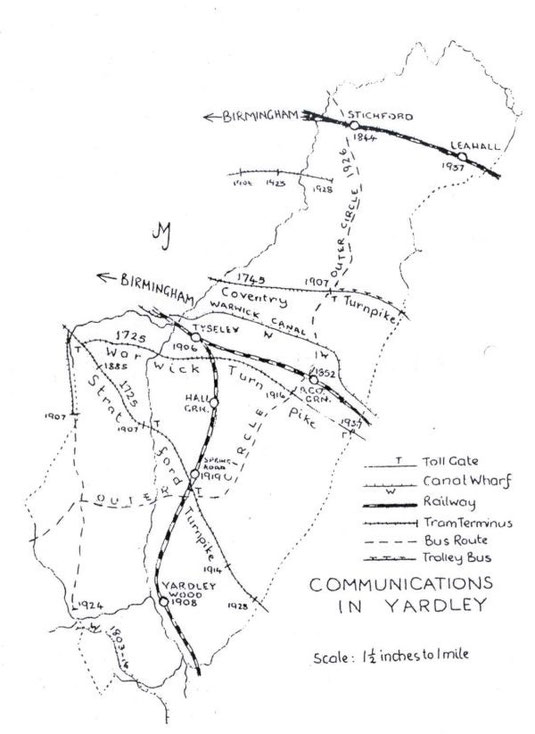
Communications
Yardley lies between Birmingham and the towns to the south and east, so that all communications with these have to cut the narrow width of the parish: there has never been an important route along its length. The main roads to Coventry, Warwick, and Stratford, which cut the parish into its four administrative quarters, were maintained by statutory labour supervised by the Overseers of Highway, but maintained very poorly. Coventry Road was particularly bad. There were only footbridges across the Cole, whose approaches and fords were impassable after rains and dangerous in flood.
The Birmingham and Edgehill Turnpike (Stratford Road) and the Birmingham and Warmington Turnpike (Warwick Road) were instituted in 1725, with tollgates at the 'Mermaid' junction, at Greet Mill,
Cole Bank (probably School Road junction), and at Acocks Green. Coventry Road was turnpiked 20 years later with a tollgate at the 'Swan'.
Greet Mill ford remained in use, so presumably there was still no wain bridge at first: in 1777, after the rebuilding of the mill, a brick bridge was placed over the tail-race. Eleven years
earlier, Greet Bridge on Warwick Road, a 'substantial stone bridge' shown on Beighton's map of 1725, was largely washed away by floods. When re-built in 1777 it had four arches, the two central
ones carrying a causeway on an island between two arms of the river. For failing to repair later damage the Yardley Overseers were indicted in 1817, and the bridge was then restored. It was
rebuilt over a single channel in 1902, as was the Stratford Road bridge in 1914.
Hemill (Hay Mill) Bridge on Coventry Road was named on a map of 1675, but is unlikely to have been more than a footbridge. Thomas Telford undertook an essential reconstruction of the Turnpike
about 1820, and the building of a road bridge, as well as the abandonment of the holloway near the top of Red Hill may date from that time. Mile-stones had to be provided after 1745: none of them
has survived in Yardley, and 18th century miles were variable lengths, but they should have been seen near the 'Swan', Greet House, Tyseley, Acocks Green, Sparkhill, Greet Mill, Hall Green
School, and Six Ways. Turnpike revenue was not always up to expectation - the Acocks Green tollgate expected to take a pound a day (Coaches 1s 6d, Wagons 1s) in 1793, took less than £293 that
year. By 1817 there were 5 daily coaches on the Stratford Turnpike. Coaching inns were well-placed along the highways - the Mermaid, Dolphin, Spread Eagle, Bull's Head, Old Crown - and there were
smithies at Greet, Tyseley, near Six Ways and the Swan, as well as three in Church End: in the mid-19th century about 30 people were engaged in services to horse-traffic through and in Yardley.
The River Cole has never been usable except by the smallest flat-bottom boats. But about 1795 travel by water across Yardley became possible when the Warwick and Birmingham Canal was cut through
the Stockfield Ridge and a corner of Acocks Green Field. High brick bridges and a short tunnel under Yardley Road were constructed, and at two wharves (Wharf Road and off Yardley Road) Black
Country coal was unloaded. The canal was complete to the Oxford Canal by 1799 : there were flyboat services, and Yardley tiles were dispatched to Birmingham and elsewhere. By 1803 the Stratford
Canal was open from Kings Norton to Kingswood, with a wharf at Yardley Wood where Dudley coal, lime and iron for local use were unloaded. Iron flyboats plied for a time. The canal reached
Stratford and the Avon Navigation in 1816.
Robert Stephenson's London & Birmingham Railway was opened in 1838, and Yardley had its station, at Stichford, from 1844. Of more concern to most of the parish, because of its central
crossing, were the Oxford Railway and its local station at Acocks Green which was built in 1852. After the abolition of turnpikes in the 1870s there were horse-buses to the Swan, and steam trams
reached Sparkhill by 1885. Twelve years later there were electric trams to the common boundary of Birmingham, Yardley, and Kings Norton, on Stoney Lane, after the city and Yardley Rural District
Council had jointly remade that road: on Stratford Road to the Cole: and on Coventry Road to the Swan: but the nearest terminus to Yardley village was Bordesley Green until 1928, and Warwick Road
did not have trams until 1916. The narrow street through Greet had a single track with signal lights at each end. The terminus was at the junction hamlet of Westley Brook, which was thereafter
developed as the 'village' of Acocks Green. The older settlement near the 'Dolphin', approached by a very narrow stretch of Warwick Road, did not have a tram service.
In 1907 the North Warwickshire Line was constructed from the Oxford (G. W. R.) line at Stockfield to the Cole Valley and Stratford. An earlier plan by another company would have brought a railway
through Sparkhill, with a station at Baker Street. Tyseley Station was built on the G. W. line in 1906, and Hall Green and Yardley Wood Stations opened the next year on the NW line. Tyseley Goods
Yard served the new industries that grew up between the canal and railway After World War I, and the NW line brought industries to Shaftmoor (Spring Road Halt 1919) and the Cole valley north of
Yardley Wood.
The City of Birmingham absorbed Yardley in 1911, and the next year took control of all tramways through the district. In 1914, the Coventry, Stratford, and Formans Road bridges were replaced: at
Greet Mill site the country and millrace brick bridges were removed, a central channel was made and spanned by two brick and stone arches, and the tram tracks were extended to Robin Hood. Under
the 1914 Development Plan, sleeper tracks on central reservations between two carriageways were begun beyond the existing ribbon building: the only tram routes through Yardley on which this could
be done were Stratford Road from Highfield to the boundary, and the extension of Bordesley Green East to Stechford (1928). Other double-track roads were begun during the 1920s and 1930s - notably
the ancient ridgeway, School Road - Highfield Road - Fox Hollies Road - Stockfield Road - Stoney Lane; and also Yardley Wood, Warwick and Coventry Roads, and Robin Hood and Brook Lanes: but
existing buildings, wartime delay, and post-war cost, have left these schemes in a most unsatisfactory state of incompleteness, causing bottlenecks and accidents to the far greater traffic than
the completed highways were expected to bear.
In the early 1920s as it was realised that the narrow lanes and awkward intersections of Yardley were unsuitable for further tram services, Corporation motor buses were introduced: two fatalities
on Yardley Wood Road by Lady Mill site in 1924 made clear the need for early improvement of the worst roads. In 1926 the Outer Circle bus route provided the first ever communication along the
length of Yardley, from Kings Heath to Stechford: Yardley village, always isolated hitherto and having no part in the spectacular development of better-served districts, was now close to a bus
route, with the result that private building began around it. The 24 bus, linking the tram terminus at Stoney Lane to Warstock, the 1A between Moseley and Acocks Green, were among the earliest of
the new, more flexible services. The growth of municipal housing in Billesley, Yardley Wood, Pitmaston, Gospel Farm, Acocks Green, Fast Pits, Hobmoor, and later Glebe Farm and Lea Hall; and
private development in Hall Green and 'South Yardley', brought new bus routes, numbering 22 in 1964, serving all parts of the ancient parish.
Lea Hall Station was opened on the L. M. S. line in 1937. Trolley buses replaced the Coventry Road trams in the early 1930s, and the route was extended to the city boundary. Diesel buses replaced
the trolleys in 1951, having already taken the place of the Stratford and Warwick Road trams in 1937. Having reached its peak about a decade ago (i.e. 1954, a decade before this article was
written), public transport is now beginning to decline, with the growth of private vehicle-ownership. As of 1964, passenger services have been suspended on the NW line and Lea Hall Station on the
L. M. line has been closed. Bus services may be expected to decline also as losses on them continue. The congestion at the 'Swan' crossing was relieved by the underpass made at vast expense.
Introduction
Overview
Foundation and ownership
Map: descriptive names
Map: geology and roads
Map: early settlement sites
Ancient roads
Communications
Map: communications
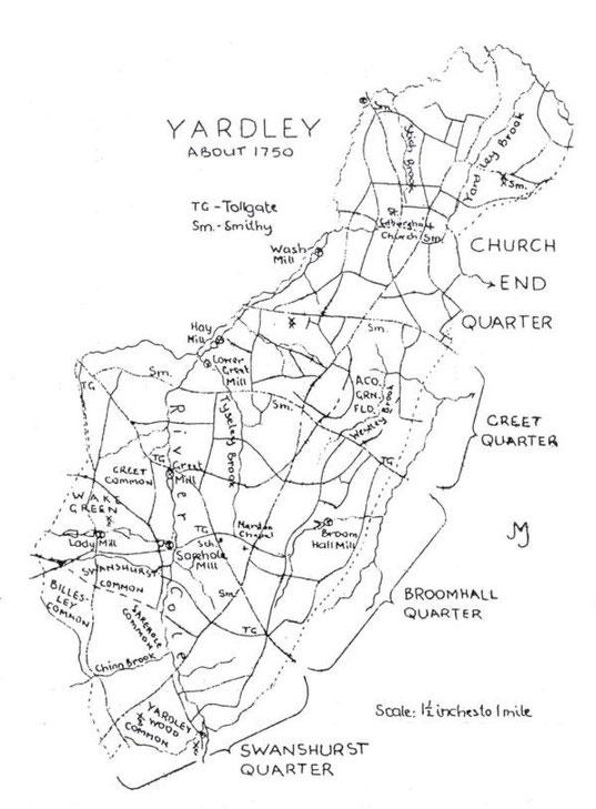
Map: Yardley about 1750
Antiquities
Watermills and windmills
Ecclesiastical history
Administration and local government
Map: Yardley Parish and Vestry prior to 1894
Map: Yardley village 1847 to 1904
Map: parishes in 1911
Map: Yardley schools in 1911