 Acocks Green History Society
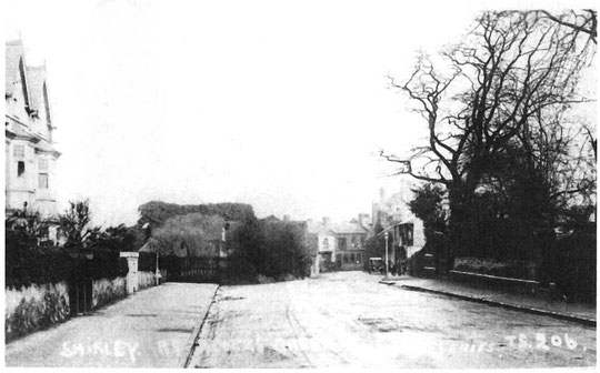
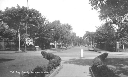
Shirley Road
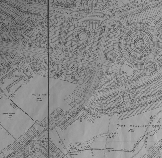
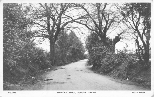
Several things have happened to this road since it was a quiet country lane. Apart from being built up with houses and shops, there was also an element of road widening, which took place between 1930 and 1931. Also, the end of the road was brought back to accommodate a larger Green in 1932, and it was widened into the larger centre as well. In fact the pavement on the western side from number 22 up to the Warwick Road almost reached to the same point in the road as the pavement on the eastern side does now. We are going as far as Oakhurst Road on the odd side, and the footpath by number 396 (the old Nine Stiles path) on the other side. The Westley Brook runs behind the houses on Shirley Road, and there are still old wells at the back of some of the houses.
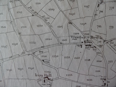
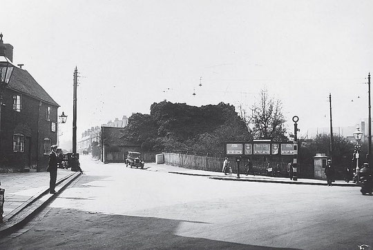
We will start with the eastern side of the road. There were some cottages at the Warwick Road corner, shown on the 1875 Cook estate map below, which were replaced by the stylish building now containing Subway around 1901. It was said to have been built as a clothing factory, but soon became a bank. Part of it accommodated a seed merchant (Pitts) as well, on the Warwick Road side. Next door to here was a short row of cottages, also shown on the 1875 map, and then a farmhouse. In 1925 the cottages had a milliner and a wireless accessories manufacturer listed in them. In 1930 two motor haulage contractors and a printer were listed, probably at the rear. The printer was still in the directories in 1945. The cottages were demolished in the early 1930s as part of the Green improvements. This left a gap, and Woolworths was listed there in 1935, and a year later Burton the tailors built a shop with snooker hall above. This has an Art Deco façade, which needs a bit of attention, but it is one of the most striking buildings in Acocks Green. Number 1 had the Polytechnic (Snooker) Club, listed from 1937 until 1957. A tobacconist was listed at 1A from 1937.
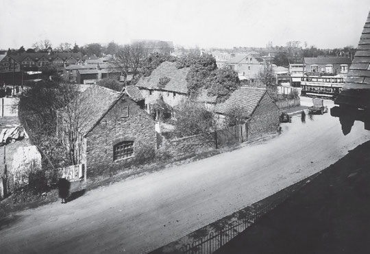
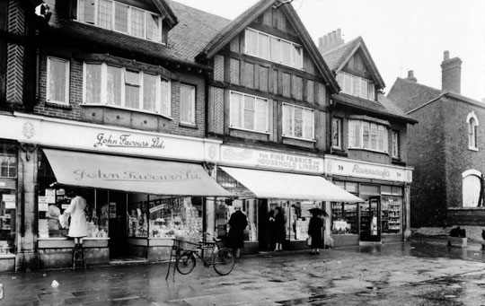
Just beyond here a short row of shops appeared around 1905. These were allowed to be built further forward than the later 1930s shops. They had a builder, a watchmaker, a boot maker, and a cycle maker in the 1905 directory. In 1912 the cycle maker was Mrs. Jane Bucknall. The farm lasted until around the First World War. Latterly the occupant was listed as a cowkeeper, which was convenient for the butcher which used to be located just beyond the bank building on the Warwick Road. After husbandry ended, the farm buildings were demolished, and the field behind the shops became a football and cricket club ground, the AGN Avondale. Fred Cowan Senior, whose long-lived café was in the 1905 row from 1921, was involved with the club. From the mid-1950s, government funding for faith schools enabled the Roman Catholic church to expand its school along the back of the Warwick Road towards Shirley Road. Around 1930, two attractive mock-Tudor shop rows appeared, filling in the line as far as the Victorian houses. According to the directories and voters’ lists, these were gradually occupied over a few years in the early 1930s.
The Victorian houses from number 41 are some of the earliest buildings still standing in Acocks Green. The ground rent date for all the properties to Botteville Road is September 1959, so it seems reasonable to date the buildings as early 1860s. Numbers 41 and 43 were called 1 and 2 Evelyn Villas. Number 45, in a different style, was called Victoria Lodge. A furniture removals business was listed there from 1948-58. Number 47 matches the others, and was called 1 Ash Villa then Silverdale. After that numbers 49, 51, 53 and 55 were numbers 2-5 Ash Villa at first. Number 49 became Ivyleigh, number 51 Ashfield, number 53 Ashleigh, and number 55 Ormonde House. Numbers 53-55 became the Warwick House Hotel around 1980, and were replaced, together with a house on Botteville Road, around 2005 with modern apartments. For a while, number 51 was a hotel annexe.
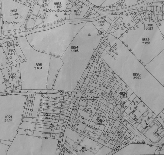
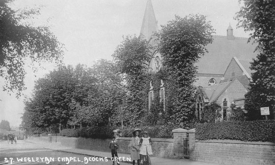
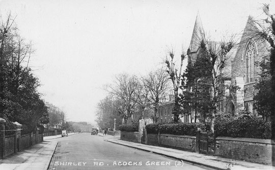
Across Botteville Road, the Methodist church was first built as a small chapel in 1863. The main extension was towards the junction in 1882. The first three houses are also probably early 1860s. Number 61 was called Wellington Villa and Leighhurst. A dance school was listed there from 1945 until 1967. For most of the time it was run by Yvonne Mason under her maiden name of Eccleston (thanks to Colin Bramley). Number 63 was Aversley Villa or Gothic Villa, and number 65 was called The Cedars. This was lived in by the Bott family, one of whose members had developed Botteville Road and given it the family name. The house is now numbers 65 and 67. This subdivision may have been done in the late 1920s. 67A, Cearl Court, is a development behind here of around 1975. Numbers 69 and 71 are c. 1925, number 73 is c. 1929. The two stylish small houses numbered as 75 and 77 were originally built as porter’s and gardener’s lodges for a large house called the Oaklands, which used to stand at the corner of Victoria Road. “75 Shirley Road was originally a pair of cottages built for 'Hy. Phillips' in 1888, architects Crouch and Butler (Solihull R.S.A. plan 6 approved Feb 8th. 1888, completion July 27th.)” (Andy Foster). They were called Arden Lodge and Arden Cottage. An optician was listed there from 1954 until 1972. He may have used one house as residential, and the other for his practice. Until the Oaklands was demolished, its grounds stretched along the road from the lodges to the house. The Oaklands may have been built in the early 1860s. It was occupied by Henry Phillips, who was in the jewellery business. He was listed in the 1861 census as a silver chain maker, probably at the Oaklands. The Phillips family were there until the early years of the 20th century. From 1929 until 1943 a doctor’s surgery was listed there. It then became residential again until around 1960. Ansells bought it and attempted to turn it into a pub in 1962, and a hotel in 1964. Both applications were rejcted. Amoco then bought it and applied in 1966 to have a petrol station and ten houses built there. This application was refused, but new houses from the lodges (numbers 83-101) to the Victoria Road corner appeared around 1967.
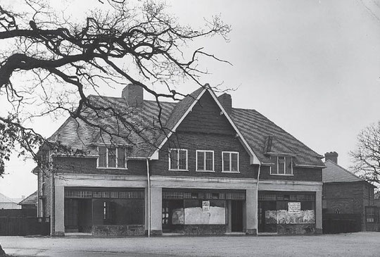
Across Olton Boulevard East, a new stretch of road intended to be a dual carriageway as part of an Acocks Green bypass, we are into ex-Fox Hollies Hall territory. Colonel Walker’s estate was sold to the city in 1925, and council houses appeared over the next five or so years, including on Shirley Road. Numbers 121-165 were there by 1929. The new shops at the Greenwood Avenue corners were opened in the early 1930s. Greenwood Avenue itself was conceived as a main avenue for the new estate, but it led nowhere, and was really a prestige element designed to impress, and to which coachloads of planners from other cities were bought to admire Birmingham’s municipal building programmes. The houses either side of the health centre date from around 1929-30, as does the clinic itself, purpose-built for the new estate. The building was given similar architectural details to other houses near here. It is worth noting that a lot of effort was made to add interesting detail to the appearance of what were ‘merely’ municipal houses. This should be a source of pride. An interesting article about the clinic appeared in 1970. It is reproduced below. A portakabin was added to the clinic at the rear c. 1987. This was removed c. 1999 when the clinic was altered and extended, adding an additional floor, modernising the façade and including a new wall along the road. Other nearby institutions also got in on the act, providing services to children and families. What is now Fox Hollies Forum at the end of Greenwood Avenue was built for St. Mary’s church in 1936 as Bishop Westcott Hall, in order to serve the estate. In the early 1970s it transformed itself into a vibrant community centre. The Methodist church provided maternity packs to young council estate mothers.
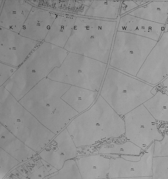
The houses from the clinic/health centre to Dolphin Lane date from around 1929-30. From Dolphin Lane, numbers 205-211 were there in 1929. Numbers 213-247 may have been built a year later. From around 1947 there was a row of prefabs at the edge of Fox Hollies Park (numbers 249-279). These were vacated from 1978-1981. Fox Hollies Park itself was part of the farmland belonging to Fox Hollies Hall, and the park pool was part of the farm. The park was made by draining, levelling and planting in the early 1930s. In the park are Bronze Age burnt mounds and the site of a corn mill, making it the most historic site in Acocks Green! There were a couple of houses from around 1930 at the corner of Oakhurst Road until a new 279, a detached house, was built in a sympathetic style next to number 281.
On the even-numbered or western side, the first building shown on the 1875 Cook estate map is Ivy Cottage and its outbuilding. Ivy Cottage was revealed to be timber-framed when it was demolished c. 1931. Miss Orsborn had to go to a house on Dudley Park Road. If you go by the line of Shirley Road as it has opened onto the Green since 1932, Ivy Cottage was well in front of the building line of the Edwardian houses next to the library. In fact it would be in the road and the triangular car park in front of the library if it was still standing. The library opened in June 1932, and was built in a field behind the house. There are two phases of building up to Hazelwood Road. Numbers 22-44 appear in directories from around 1906, and are not on the 1904 O.S. map. There are two styles, the first seven, then another group of five. Their names were Kootenay, Demeure, Vitnau or Bitznau, Stavordale, Ravenswood, Hazeldene, Ivydene, The Bower, Inverurgie, Sherwood, ? and Rothley. A music teacher was listed at number 28 from 1912 to 1920. Number 32 was listed as the Warwick Studio (photographers) from 1933 until 1955. Number 34 was listed as a doctors’ surgery from 1935 until 1950, and number 42 from 1929 to 1933. Number 36 was listed as a costumier from 1929 to 1937. Number 44 is built right next to number 46 (Ivanhoe), but they are of different styles, and this and numbers 48-58 are earlier, belonging to the around 1890. The corner house has been a dentist’s practice for nearly a century. Mr. Parker had started at number 80 around 1923, and moved to number 58 around 1927. There appears to be one name missing from directories for these houses. Number 48 appears to have been called Glenwood, number 56 Holmlea, and number 58 Sunnyside. We have only found the names Inglesant and Boness for numbers 50-54.
Numbers 60 to 82 appear on the 1888 O.S. map. Former names are Woodbourne, Ferndale/Hillcrest, Rosedale/Saxondale, Havelock Villa, Lynton Villa, The Croft, Glenora, Penrhyn, Firholme, Sunnyholme/Abermaw, Woodleigh and Laurel Villa. Numbers 84-6 do not appear on the map , but number 86 (Albert Villa) is listed in an 1890 directory, so we can presume that number 84 (Heatherlea) was also present then. Number 88 (The Willows) was shown as a detached house on the 1888 map. The plot has been occupied by two semis since around 1939, numbers 88 and 90. Privately-built semis numbers 92-118 date from around 1929. Number 60 was listed as a dance school from 1940. Jack and Joan Cooper’s Academy lasted here until 1964. They supplied female dancers for pantomimes, seaside entertainments, circuses and revues. A tailor was listed for three years from 1948 at number 62. A district nurse, Frances Bristow, was listed at number 82 in 1930. She is then listed as a midwife until the 1937 directory. Number 90A, behind the houses and reached by a passageway, is listed as a florist, then a nurseryman, from 1944 until 1963. The site became part of Hazeltree Croft shortly afterwards. A music teacher was listed at number 96 from 1932 to 1942. A doctor Abbott was at number 118 from the 1930 directory until 1933.
Across Olton Boulevard East at number 164 in the 1930 directory was another doctor named Campbell. Municipal houses numbers 122-162 date from 1928-9. A music teacher was listed at number 130 in the 1960s. A midwife is listed at number 140 in 1929. Joan Connolly appears at number 312 in the 1931 directory, and then gets married, and is listed as a midwife under her married name of Shorthose (Shorthouse?) until c. 1937. A doctor’s surgery was listed at number 164 from 1929 to 1940. The next sequence is numbers 228-246, also from 1929. All these are municipal. Number 248 is a detached dormer bungalow (first listed in the 1930-1 voters list), the next number is 266, a wide bungalow. This was built c. 1924 and was initially lived in by a man called Arthur Ilsley. He was a gunmaker, known for upmarket shotguns. By 1927 Arthur and his wife were listed at the new Catholic church on the Warwick Road. It is tempting to wonder if they were related to the late R.C. Archbishop, Edward Ilsley. However, by 1935 they were running a pub in Aston! While they were at number 266, they called it Oakdene. Around 1929 a Mr. Maxfield turned this bungalow into a shop, later run by Tippetts, and Noakes. It was last listed as a grocer’s shop in 1972. This row looks very residential now, and this would have been an interesting thing to see. Numbers 268 and 270, also wide bungalows, also date from c. 1924. Numbers 272-4 are detached, and date from c. 1928. In 1930 a Dr. Iskander is listed at number 272, but the year after and until 1933 the entry is under number 284. Numbers 276-8 are semis and were built c. 1939. Numbers 280-2 are bungalows from c. 1927. Number 282 may have originally been called The Ranch, and number 284 Philomena. Then there was a gap for school playing fields, later closed off with numbers 286-94 as part of the Foxglove Close development of around 2001. Numbers 312-326 are semis listed in the 1930-1 voters list. Between 326 and 348 now is the entrance to Fox Hollies Leisure centre, opened in 1986. Hartfield Crescent school canteen was listed at 328 in 1965. Numbers 348-54 are semis first listed in the 1930-1 voters list.
A map of 1939 shows a long building stretching back from a little way behind the road after number 354. This was the first incarnation of the Sub-Post Office/shop. The first reference we have found is in a voters list of 1925. By 1926 number 358 is listed as a shop, and number 356 as a shop in 1932. Number 358 is a Sub-Post Office in a directory of 1936. Number 356 is listed as a TocH club from 1940-44. A number 362 is listed as a wine dealer in 1940. There is no number 360. In fact, numbers 362-8 are a new building of c. 1947 on a vacant plot. Initially only number 362 contained a business, once again selling alcohol. Number 358 was also rebuilt, but further forward in line with the other frontages. Numbers 370-396 are first listed in a directory of 1935.


It is now possible to see the sequence of large-scale O.S. maps online at www.old-maps.co.uk. For this road enter the postcode B27 7NN, and choose the 1:2,500 maps up until 1952-4 (there is no 1937 map for part of this road at this scale). Use the plus and minus buttons to change how close up you wish to see the houses. The map can be dragged by using click and hold as normal.