Acocks Green History Society
The archaeology of Acocks Green
Our thanks go to Dr Michael Hodder, Birmingham's Planning Archaeologist, for most of the text on this page.
Acocks Green's archaeology includes burnt mounds from the Bronze Age, medieval moated sites, medieval open field boundaries, and a water mill. Acocks Green's burnt mounds have been listed as a Scheduled Ancient Monument. An explanation of what burnt mounds are thought
to have been can be found here. Michael
Hodder's book Birmingham, the hidden history, discusses burnt mounds (pp. 28-44, especially p. 37 and fig. 18).
There were several moated sites in Acocks Green, at Hiron Hall, Broom Hall, Tyseley, Pearl Grove and east of Gospel Lane: for information on moated sites, see here. Please note that on the Tithe Map extracts shown below, north is to the right.
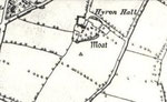
Hiron Hall Moat
Moat arms to the south and east of "Iron Hall" can be seen on the 1st edition OS map
Broomhall Moat
Moat arms can be seen on two sides of the house on the 1st edition OS map
Tyseley Hall
The 1st edition OS map shows an L-shaped pond to the south-east of Tyseley Farm
Pearl Grove Moat
The 1st edition OS map shows an L-shaped pond forming the north-east corner of the moat and a change in the direction of a field boundary possibly
indicating the south-west corner.
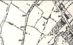
Warwick Road/Grattidge Road
The moat is indicated by an L-shaped pond, on the 1st edition OS map, forming the south-west and south-east moat arms. A desk based assessment
and evaluation were conducted in 2007. Excavated trenches revealed good survival of archaeological features in the south-east part of the site, consisting of a pit-like feature and cobbled
surface within the interior of the moated enclosure. Further north-west, severe truncation had removed all archaeological traces with the exception of deeper features. The truncated base of the
moat was found. A possible leat ran into the moat from the south-east. One sherd of medieval pottery and two fragments of medieval roof tile were found in the moat. The archaeological
report can be accessed by entering the search terms 'Warwick Road Grattidge Road moat' in a search engine and choosing the archaeology data service link.
Former open fields
The open field boundaries can be seen on the Tithe
Map.
Broomhall Mill
The water mill was in what is now Fox Hollies Park. It was known as Broomhall Mill. A sketch map is below. For
information on water mills see the booklet Archaeology and Industry.