Acocks Green History Society
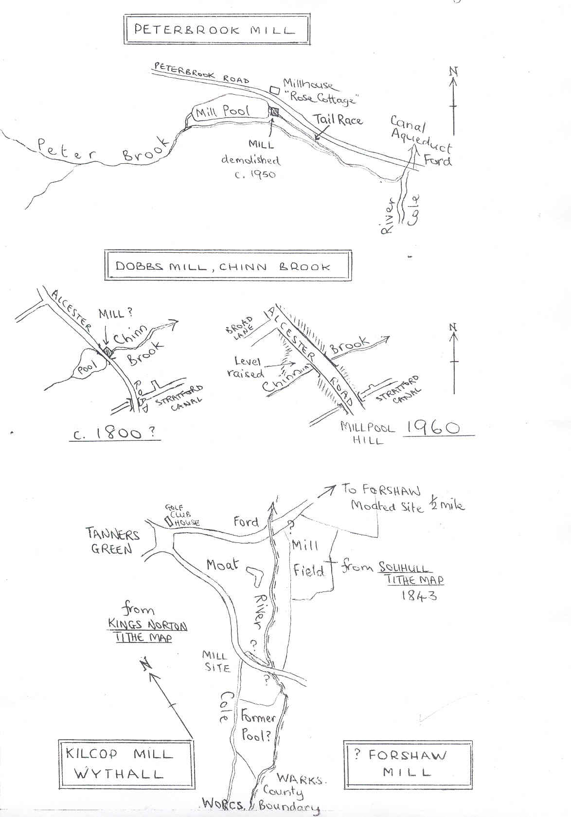
Peterbrook, Dobbs, Crab, Kilcop and Forshaw Mills
Peterbrook Watermill, Solihull Lodge
This small corn mill, (described as an Oatmeal Mill in 1843), was demolished about 1950, after being unused and derelict for more than thirty years. A cruck house, timber infilled with small brick,
it may have been sixteenth century or even earlier. It had a large chimney which may at one time have topped a forge.
The attractive pool, rather more than an acre in extent, survives between the road and Peter Brook, which forms the County boundary. Opposite the nettle-grown foundations and half-filled tail-race
is the mill-house, an eighteenth century building now called Rose Cottage, heavily panelled and much altered within. It was the property in 1896 of Stanbury Eardley, the eccentric lawyer who later
went to live in ruined Swanshurst. The last miller was one Else.
(Informant, Mrs. Scrivener, Rose Cottage)
? Dobbs Mill, Alcester Road
A mill of this name is shown on the Sharp map of 1787-9, and may be correctly named. But as the Dobbses were the Lifford family, I wonder whether
the name has been transferred in error from the Lifford mill, which is not far away on the map. It is not unlikely that the family owned both mills, of course. Lacking further information, I think
that this may have been the manorial mill of Monyhull nearby: it does not appear on nineteenth century maps, although the pool is shown on the 1840 Tithe Map of Kings Norton, beside the highway. The
name ‘Millpool Hill’ survives for the southern slope of the Chinn valley at this spot, and gave the first clue to the former presence of a mill. No trace remains, the pool having been infilled and
the valley much altered by the raising of the Alcester Road. Some ancient brickwork is to be seen in the stream bank on the east side of the bridge, but this is probably the remains of the earlier
Turnpike bridge.
Crab Mill, Chinn Brook
The name ‘Crab Mill Lane’ north of Headley Heath is the only clue to the mill’s existence which survives. The brook is very small here, only a mile from
its source, and a mill might have been horse-powered rather than water-powered. The O. S. Two-Inch Field-Sheet shows Crab Mill, but its exact position is hard to determine.
Kilcop (Kilcups) Mill, Tanners Green
This, the manorial mill of the sub-manor of Wythall in Kings Norton, is mentioned as ‘Wihtewrthemilne’ by Dugdale in 1656. This is
‘Wythworth’: the manor with water-mill called Kilcupps was sold in 1633 by William Cowper and his wife Martha to William Chambers (V.C.H. Worcestershire, vol. 3, p. 186). The mill is shown on
Beighton’s map of 1725, beside but not on the river: however Beighton is not to be relied on in such details, even to which side, and hence which manor, of the river. The exact site of the mill is in
doubt. Dr. Hetherington states that the present golf-club house is the former mill, but this is unlikely, since it is on the green, well above the river and unable to receive water from it except by
a contour channel one and a half miles long. The most likely site is on Mill Lane, just north of the County boundary, which here leaves the river to follow a deep ditch. This may have been the former
river channel or the south bank of a long mill pool. (See sketch map)
The miller at Kilcop in 1779 was William Grevis: as he had forty-seven children and grandchildren, it is not surprising that his descendants were still to be found at Tanners Green sixty years later. By then, however, the mill had disappeared: it is not shown on the 1840 Tithe Map.
? Forshaw Mill
The 1843 Tithe Map of Solihull shows ‘Mill Field’ on the east bank of the Cole just to the north of Mill Lane: the lane joins Tanner’s Green and the long-deserted double-moated site of Forshaw
manor-house. Forshaw was a sub-manor of Solihull in the thirteenth century, and may well have had its mill at this, the nearest point on the Cole. However, the mill from which the field took its name
is more likely to have been Kilcop, which was only two hundred yards away on the opposite bank, and which long out-lived a Forshaw mill if over there was one; the moated site was deserted in 1725,
being shown as an abandoned village (Beighton map).
Provisional list of Cole valley watermills
Peterbrook, Dobbs, Crab, Kilcop and Forshaw Mills
Colebrook Priory and Old Mills
Trittiford Mill
Broomhall and Lady Mills
Sarehole Mill
Greet Mill
Possible mills in Greet and Tyseley, Medley's Mill
Hay Mills
Wash and Stechford Mills
Babbs, other Sheldon, Kingsford and Coleshill Mills
Sources