Acocks Green History Society
Introduction
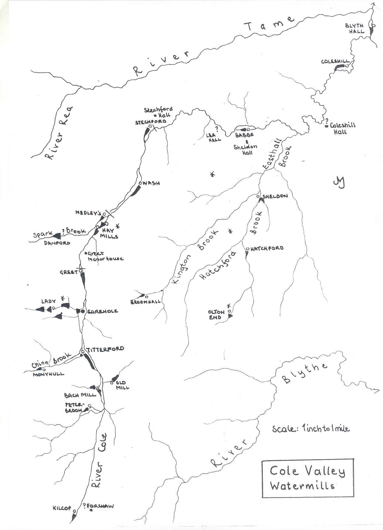
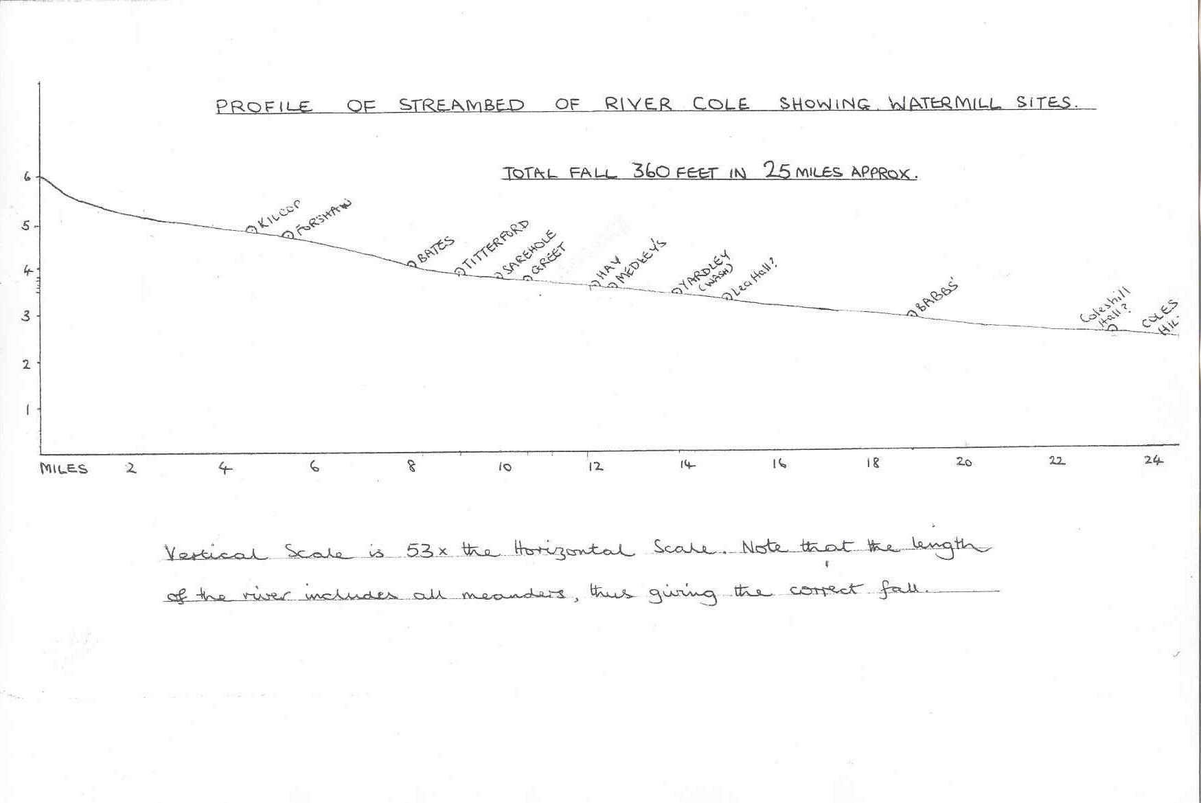
The river Cole is about twenty-five miles long. It rises, at six hundred feet above Mean Sea Level, on the lower slopes of Forhill, one of the south-western ramparts of the Birmingham Plateau, and flows largely north-eastward across the Plateau, to enter the river Blythe below Coleshill. The source of the Cole is very near the main watershed: its tributaries are few and very short except in the lower reaches. Obviously, therefore, the river must be small in flow. The streambed has an overall gradient of one in 364, but the central part of the river where most watermills have been sited has a gradient of one in 488, or ten an a half feet in a mile. Clearly, the Cole cannot be a swift stream. It is subject to very rapid flooding, due in part to the small gradient and the meandering of its course, and also to the nature of its catchment area. This is heavy clay, variably covered by drift, and there is a fast run-off. Cutting-down of the former extensive forests, which retained rain-water, releasing it slowly and fairly uniformly to the river, has increased the tendency to fast shedding, as has modern field-drainage: lacking replenishment from large tributaries, Cole floods subside as quickly as they rise. In times of drought, the highest reaches are often waterless.
Despite these disadvantages - not unique to the Cole, of course - the river has in past times served at least thirteen watermills, and its tributaries perhaps nine more. When water was the only source of fairly constant power, it had to be made the most of, and this unimportant stream was probably as fully employed as any outside an industrial area, particularly in the later eighteenth century.
The use and mechanics of the waterwheel were known to the Romans, and there were probably watermills in Britain during its centuries within the Empire. But the Cole valley, like Arden generally, had nothing to offer, its marshy trench and bordering deciduous jungle being unfavourable to settlement: the only known site was on Grimstock Hill north of Coleshill, and though it is possible that a mill existed near the ford in those times, this can never be confirmed. Otherwise the nearest Roman work in our area was the later-named Ryknild Street, which crosses the Cole three hundred yards from its source.
Saxon watermills abounded - there were 7500 of them recorded in the Domesday Book, 165 of them in Warwickshire and Worcestershire manors. Of these, 107 were on the Avon or its tributaries, and the sparseness of population in Arden is reflected in the small number of mills recorded therein. For the Cole, only one is given, that at Coleshill, which rendered 40d. There were apparently no mills at all on the Rea, but the Blythe powered five at that time.
In l086, and indeed for about 250 years from the tenth century, the manor of Yardley was owned by Pershore Abbey. This very wealthy establishment on the Avon had five mills, according to Domesday. It
seems strange that no use had then been made of the nine miles of Cole frontage within its bounds: however, the combined population in l086 of Yardley and Beoley, which were linked in the survey, was
less than one hundred, and there was no religious house in either manor. Still, a mill was a source of revenue to the manorial lord, who levied thirlage on all grain ground therein, and sold the fish
and eels caught in the weir-traps, so that one might have expected the Abbey to be more enterprising.
After Coleshill, the first mill of which there is evidence is that of Stichford. In 1249-50 it was the property of Giles de Erdington, whose seat was Stichford Hall, across the Cole from Yardley. In the fifteenth century Hay Hall, Greet, Lea Hall and Stichford were sub-manors in Yardley, and all had a mill, as did Broom Hall. Babbs Mill was the property of nearby Sheldon Hall, and Coleshill Mill of the Old Hall one and a half miles downstream. The dates of construction of these mills is not known: indeed it is rare to know such dates, and first documentary references that survive give no indication of the mill’s age. It is known that a new mill was erected in 1385, for in that year the Earl of Warwick, then the Lord of Yardley, gave the tenancy of a millsite to one Roger Bradewell and furnished timber to build the mill in return for an annual rent of 6s 8d. This might have been Yardley Mill, otherwise Wash Mill, but there is no certainty: it was called ‘Wodemyll’ in its early days, but this does not help identification, since all mills were made of timber and so the name must refer not to its material but to its site, which in a heavily wooded manor could be anywhere on the river. It is most unlikely to have been a windmill, for these appeared locally only when water resources became inadequate, and that was much later. Two unnamed mills were annexed to the manor of Yardley in 1593. Its Lord, Benjamin Grevis, had two watermills and one windmill in Yardley and Moseley in 1689. We can only guess which of the known mills these were.
The first synoptic picture is obtained from Henry Beighton’s Mapp Of Warwickshire, surveyed 1722-5. He does not show the Cole between Solihull Lodge and Greet, as this is in the Worcestershire manor of Yardley, so that there is no record of Titterford (probably not then built), Lady and Sarehole Mills: those shown are Kilcop, Bach Mill, Old Mill Pool, Greet, Boreing Mill (Hay Mill), Stichford, Babbs Mill (on the left bank instead of the right), and Coleshill. Apart from Old Mill Pool on Shirley Brook, no tributary mills are shown, although there are two unnamed pools on the Hatchford Brook near Olton. A postmill is shown on Red Hill above Hay Mill, and at Wells Green, the site of Sheldon windmill is shown as Old Mill Hill. The Beighton map is neither complete nor wholly accurate, but it has provided valuable information.
Because the Cole has neither a good and steady flow nor a steep gradient, the use of large Overshot wheels would require very long head and tail races to concentrate the total fall of more than a mile of the river at one point: it would seem likely therefore that the Cole mills were originally the simple Undershot or paddle type, with possible later refittings of small-diameter but wide Overshot wheels. Smeaton’s development of the Breast wheel in the 1750s was employed in the later rebuildings of such mills as I have information about, and was probably in general use during the last decades of the water-power era. For a diagram and description of the three wheel-types, see my essay ‘Local rivers as sources of power’.
After many centuries of service, watermills were succeeded by more powerful and reliable power units – Watt’s rotative steam engines and their improved successors. Unaffected by drought and flood,
engines could be sited near to canal and railway, to fuel supply and to labour. Despite the initial cost, they were so adaptable and efficient as to be able to compete with and eventually to
supersede watermills. From varied industrial processes the mills reverted to corn-grinding, but that too became uneconomic: on the Cole, the spread of Birmingham was reducing the number of local
farms, and after World War One only the oldest of them all - Coleshill - was still at work, and that only intermittently until 1930. Of all the buildings, only two remain: Sarehole and Babbs Mill,
and only Sarehole retains its wheels and some of its works.
It is noteworthy that the mills of Titterford, Sarehole, Greet, Hay, Medley, Stichford, Babbs, and Coleshill, were situated just above fords, and that Dobbs, Colebrook, Lady, and Olton End Mills had roads across the weirs just above the wheels. It seems to me most likely that the mill in most cases preceded the ford, the shallows created below the weir being made use of. The diversion of the Stratford Road to cross just below Greet Mill is a very clear example.
Provisional list of Cole valley watermills
Peterbrook, Dobbs, Crab, Kilcop and Forshaw Mills
Colebrook Priory and Old Mills
Trittiford Mill
Broomhall and Lady Mills
Sarehole Mill
Greet Mill
Possible mills in Greet and Tyseley, Medley's Mill
Hay Mills
Wash and Stechford Mills
Babbs, other Sheldon, Kingsford and Coleshill Mills
Sources