Acocks Green History Society
The waters of Yardley: settlement, communications and industry
On first reading this title one thinks of flowing water, the River Cole and its tributaries, of standing water such as the
attractive pools of Swanshurst Quarter, and artificial waterways - the two canals which cross Yardley manor and parish. But there are other aspects of water to be considered: water underground
and on the surface, and its effect on natural vegetation, settlement, occupation, and travel: water to power and serve industry: water a source of food: land drainage and sewerage: excess or
shortage of water. Insulated as we are by modern technology, we can still be affected by too little water, as in the droughts of 1976 and 1984, and by too much: balancing lakes must even out the
Cole flow, while a catastrophically wet summer can ruin a programme of outdoor events, as happened in 1972 to the Yardley Millenary Festival.
Let us consider the conditions and prospects met by the first Saxon colonists of Yardley, probably in the seventh century. (Earlier settlement there may have been, but it has left no known traces
except the ridgeways which may well be prehistoric). The Hwiccan (West Saxon) immigrants were part of a slow movement of people, probably in small kinship groups, northward from earlier
settlements on Avon terraces. They followed ridgeways, tracks which kept to high, clear ground with firm going. In Yardley these were on the line of Highfield, Fox Hollies, and Stratford Roads,
Stockfield, Yardley, and Church Roads. Moving down the flat-topped plateau between the marshy Cole valley and tributaries to the east, they had thick oak forest on both sides. On reaching a track
which crossed their own, they were faced with a mile-wide tract of wood: but a narrow path led northward, so leaving behind what would become Coventry Road they pressed on until they came to the
ridge-end, overlooking Stichford. The river made great loops at their feet, forming a barrier, a border, on two sides. The lightly-wooded spur of sandy soil could be easily cleared and ploughed,
so the colonisers made their first great fields thereon and built their dwellings around the edges. The sites were dry, but springs flowed from the drift cap: stockponds and fishponds could be
made on the rills, and shallow wells provided ample water. In complete contrast, the clay bedrock of Yardley, hundreds of feet thick, is impermeable: being itself water-bound it retains water on
the surface, where it mixes readily with it to form sticky mud. Oak forest thrives on clay and permits dense undergrowth to grow beneath. Leaf-fall creates a rich but very soggy topsoil. On the
gentle valley-sides in Yardley, where drift deposits have been removed by post-glacial floods, the forest was impenetrable save where animals had made trails to fords and where hollows were too
wet for oaks. The silt-filled valley floors were wide bogs, impassable except where drift patches had survived to make safe crossing-points. Stock could be grazed on the river meadows only in the
driest weather, but they would provide hay crops for winter feed.
In this region of plateaux only watercourses provided ready-made boundaries. Of Yardley's 17½-miles perimeter only 7 are not along streams, and for 2½ miles on the east side the boundary
parallels Kineton Green Brook: evidently the Anglian settlers thereabout had already laid claim to both sides of the brook, whose meadows were essential to their pasturing, and the Yardleians had
been obliged to accept the edge of the wood as their border. Between the bounding streams tracks marked the limits of the neighbouring vills, either already in existence when negotiations were
completed or trodden out thereafter in annual perambulations. It is noteworthy that the Charter of 972 refers to watercourses only where they cross the boundary: the implication is that if a
brook formed the border it was indisputable and therefore needed no recording.
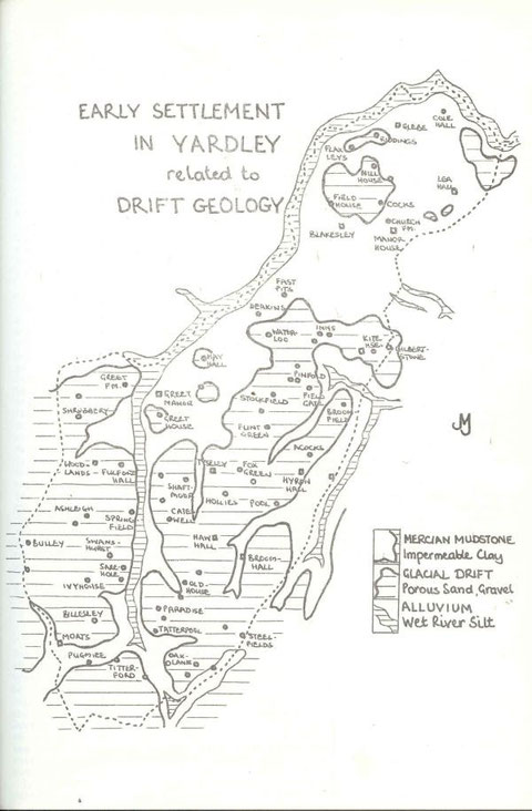
Since the field edges on drift were good sites for dwellings, why is the village of Yardley built on clay? According to the Geology Map there is no drift so far south. But the -ley ending, as
also in Blakes- ley and Lea which the map shows as settlements on clay, indicates a clearing, and this must have been a natural one in each case. So there must have been stony ground at these
sites, relatively clear of wood and providing at least a small water supply. All were moated sites, whose defences were filled by brook, spring, or high water-table, and all were occupied for
many centuries, so water supply must have been adequate if not copious. Because the manor house was where it was, the first and later churches were built close by, and a linear village developed
along the 'churchway'. It was never more than a hamlet: even by Georgian times it contained no more than forty buildings of all kinds. In that period the poor and dirty water obtainable from
wells had to be supplemented by supplies brought by cart from elsewhere. Of old sites away from the village only a dozen are on clay, 70-odd are on drift, and many of those are at drift edges,
where springs debouched.
The first fields of Yardley, overlying the ridges between the Cole and the Stich and Yardley Brooks, were extended northward to join clearings made on the Flaxleys drift patch: the necessary
clearances were 'Riddings', land ridded of trees. A small communal field-system was established at Lea. But there was no extension southward from the original ploughlands. The thick wood which
stretched, in modern terms, from Bordesley Green East to Coventry Road, was to be cleared late and slowly by individual farmers on its periphery - Blakesley, Fast Pits, Gilbertstone, and others.
The circumstances of the making of a secondary field system south of the forest cannot be determined now. Were its founders younger sons from Yardley seeking land and freedom, or later comers
from the south? Was 'Tenchley' (AcocksGreen/Stockfield) already in existence when Domesday Book was compiled, or was it established at a time of population growth thereafter? Certainly by the
late 13th century there were more householders 'of Tenchlee' than of the parent vill. Tenchlee's fields eventually stretched north to Coventry Road and south to Arden Road, west to Stockfield
Road and east to the meadows of Whisley Brook, whose meadows were used for pasture and hay-cropping.
The last group settlement in Yardley was that of Greet, a sub-manor. Its name expresses the importance of drift in colonisation and river-crossing, because it means grit, gravel. The fields
overlay Sparkhill, and the stony crossings of what became the Stratford and Warwick Roads were both called Greet Ford. All other settlement sites in Yardley were assarts, individual ventures. Hay
Hall was a prime example of careful siting, being an enclosure of the little patch of drift on which it stood, fenced to keep animals out of its crops, with its own island water supply. Greet
House and 'Tyseley Grange' (a mis-naming in Victorian times of a Stuart farmhouse) stood at the edge of similar small patches. Later assarts were necessarily at the edges of the manor, often
using the boundary brooks to fill moats.
Travel between these farms and hamlets was along the drift ridges as far as possible. Birmingham market became important to Yardley in the Middle Ages: surplus produce could be sold there and
necessities bought. The most direct route from the village was down Yardley Green Road, which became worn into a holloway and a watercourse in rain. It led to Rotyford, a bad clay crossing: its
name means 'slippery ford' and tells its own story. Waggons and horses used the unpaved fords, but by Tudor times there were flimsy (and often flood-battered) timber footbridges over the river
and some streams. Millweirs made excellent causeways, as did pool dams: at Greet, Monyhull, Lady, Bach Mills, and at Danford and Deep More, roads use the convenient embankments. It is noteworthy
too that fords employed the shallows normally found below weirs - as at Titterford, Greet, Medley's, Stechford Mills.
Turnpike Trusts improved crossings in the later 18th century by lowering the approaches and paving the fords. Counties and parish overseers built wain bridges: Rotyford's New Bridge was new in
1810. The Coventry Turnpike bypassed Yardley and Sheldon villages. Though much of the road is on drift, the ascent of Red Hill is in clay: the deep holloway near the summit, a Cole tributary in
wet weather, was abandoned by Telford's engineers when the road was improved early last century as a highway to Holyhead. Parishioners were obliged by law to maintain the roads, even the
turnpikes, and especially the 'church way', the ancient ridgeway through Yardley to St. Edburgha's. Even so, the difficulty experienced in reaching the church along deep-sunk lanes and wide
strips of morass led Job Marston to leave money and a site for a chapel opposite his house at Haw Green - whence Marston Chapel, now the Church of the Ascension. The church way north from
Coventry Road - across clay - became so worn and wet that it had to be raised on 'the long causeway', whose name is recalled in that of a cul-de-sac off Church Road. There were no riverside
roads: Priory Road in Yardley Wood is on the valley side, above flood level. The two Stoney Lanes, as their name implies, were on firm gravel alongside the Spark and Stich Brooks.
While the river was an obstacle to travel, it conferred benefits upon the manor which should not be underestimated. Its hay crops, fish, its use for navigation - by punt-like flatboats - and
particularly its power, were valuable assets. Until the Steam Age, the only sources of energy were the finite strength of men and animals, the fitful wind, and the force or weight of water. The
Cole was first used at Greet Mill in the 13th century, and 'Woodmill', presumed to be Wash Mill, was recorded in 1385. Probably all the known Cole mills except perhaps Titterford were in use
during the Middle Ages, and all originally built for corn-milling. Titterford was 'new-built' in 1783, with a 7½-acre pool fed by a long Cole leat and by Chinn Brook: its tail-race still flows.
Sarehole, fed by Coldbath Brook, also received Cole water by leat after 1768, and the mill was rebuilt shortly afterwards. It had two wheels, for corn and industrial processes. Greet, manorial
mill of Greet Manor, was rebuilt in 1775, using the ponded river. It was both a blade and a grist mill. These mills were expensively rebuilt to produce flour for Birmingham, whose waterpower was
fully used for industry. Greet Mill went out of use in 1843 and was demolished: shortage of water, diverted by four or more mills upstream into their pools and released only when they were
working, was probably the chief cause. Hay Mill was engaged in boring and grinding by early Georgian times. It was replaced by a larger mill and pool downstream about 1830. Waterpower was
abandoned three decades later, but the site is still industrial, a large wire works. Broomhall was a little corn mill which went out of use a century ago. Lady Mill was employed in wire-drawing
until about 1830. Wash Mill was always a grist mill: rebuilt in the 18th century, it worked into this century and is demolished like all the others except Sarehole.
Millpools were always fishponds too. Fresh fish were sure of a ready sale especially in winter when only salted meat was available. Other pools made solely for fish were Coldbath and Swanshurst
Pools, still surviving, and some smaller ones. It is probable that stew-ponds were attached to all large houses which had adequate water. Manorial lords, Grevises and Taylors, jealously guarded
their rights to river fish as to game in Yardley.
In the 1790s the Birmingham to Warwick Canal was taken over the Cole and Hay Mill headrace on an embankment lined with puddled clay and two brick aqueducts, and through Stockfield ridge by a deep
cutting with a short tunnel under Yardley Road. The route was well-chosen: summit level was maintained along the side of Spark Brook valley, with a feeder from the brook entering at Anderton Road
Wharf, in a curve beside and above the Cole, then up and down valleys which cut into the ridge on both sides. Sand and gravel from the cutting were used for banking elsewhere, as was material in
the next cutting near Woodcock Lane. Brooks were tapped wherever possible, notably Whisley Brook near Elmdon Road. Wharves were made on both sides of the tunnel: bricks and tiles were loaded at
the western, coal unloaded at the eastern side. Yardley clay was excellent for firing: many farms had small kilns to provide winter work, and the canal exported hundreds of thousands of bricks
and tiles in the nineteenth century. Clay pits in croft corners, dug out to supply the kilns and also to provide fertile clay for spreading over drift, soon filled with water and were useful
stock ponds in dry seasons. Flyboats took passengers swiftly to Birmingham, and from 1799 to Oxford and London. With improved turnpikes, drained, graded, and bridged, and smooth water transport,
Yardley folk were able to travel more easily.
Apart from kilns and rural crafts, the only industry in Yardley a century ago was tanning of leather. For this work hides, oak bark, and water were needed, and Yardley had plenty of all three.
Muscotts was the last firm, surviving in Tannery Lane (Amington Road) until a decade or so ago. In the mid-19th century land-drainage was going ahead fast. The last of Yardley's commons and open
fields had been enclosed. Roads of standard width and construction, hedges and ditches, were provided. The valleys had already been partly drained by ploughing at right angles to the river: in
'The Dingle' during dry weather the brown ridges and green furrows are clearly visible. The laying of earthenware pipes in the hollows completed the drainage of meadow and bog, making the valleys
usable by stock and accessible to people at nearly all times.
In the extreme south of the manor the Stratford Canal was not completed until 1816, but two decades earlier the inhabitants of Swanshurst Quarter had been able to go to Birmingham in one hour by
water. From a junction with the Worcester Canal at Kings Norton, the canal came along the Chinn Brook valley, curving and cutting through Yardley Wood Common about 1795. It brought coal,
limestone, and wire for back-yard workshops to wharves at Warstock.
Railways brought suburban development to Stechford and Acocks Green. Water came from garden pumps and hydraulic rams. Houses in Stechford backing onto the Cole were given fishing rights, which
were worth having then. Piped water reached the populous parts of Yardley in 1890, and once the Elan Valley reservoirs were connected to the City's system there were ample supplies for industry,
domestic use, and drainage (1904). The central areas of the Rural District were drained down Whisley Brook valley to a sewage farm in Deep More. By the end of the nineteenth century, the Cole
Eastern Sewer had been constructed by Solihull Rural Sanitary Authority, with works at Cole Hall. A branch was made down Yardley Brook, and others have been added. Since Yardley joined Birmingham
the main sewers have been extended to Minworth: Cole Hall Works has been closed and the area landscaped. In the 1960s Hall Green Sewer was laid down the Tyseley Brook.
Yardley Rural District Council foresaw the rapid development that would follow the improvement of public transport - the North Warwickshire Railway in 1907, and the intended extension of
tramlines - and wished to save the Cole from the Rea's fate, confined in a deep brick channel and walled away from view. It therefore proposed a green riverside strip throughout the District's
nine miles of the Cole, with a made-up path. This plan was adopted by Birmingham City Council, and has been largely implemented. Parks, recreation grounds, playing fields, and allotments border
the river from Shirley to Kingshurst. Allotments north of Stratford Road, and the industrial blight of Greet/Hay Mills had prevented completion. The opening of The Ackers and the bridge nearby
mean that now the gap is filled, and it is possible to walk at Cole-side from Solihull Lodge to Bacons End.
New roads flank the Cole valley on both sides, bridges have been rebuilt, and one new highway (Bordesley Green East) crosses it. River works from the 1920s have removed millworks, straightened
the channel, installed weirs, and recently made balancing lakes at Hay Mills, Stechford, and Kingshurst. The Cole is cleaner if duller, but trout have yet to return. The valley is watched over by
conservation groups: birds and animals use it as a corridor of movement. The Kingfisher Project and The Ackers Trust are making ponds to attract water-birds. There are plans to incorporate canals
and disused railway lines with the valleys in a city-wide pattern of greenways. Sarehole Mill has been restored and water from Coldbath Brook fills its pool and turns its wheels once more.
'Moseley Bog', a millpool bed higher up that brook, is saved from the drying-out which would have destroyed its distinctive wetland life. Titterford Pool has been dredged, so that its islands are
again refuges for birds, and Swanshurst Pool is as attractive as ever: but Coldbath, hidden away on Moseley Golf Course, is only half its original size due to silting.