 Acocks Green History Society
Yardley Road
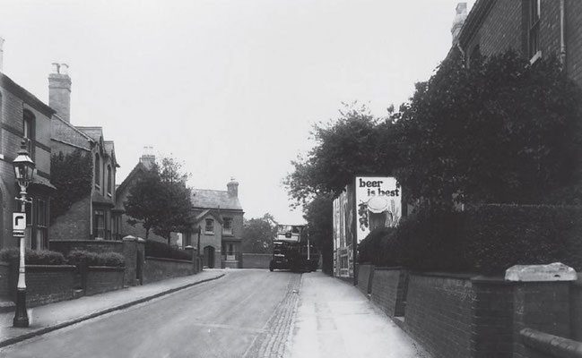
For the purpose of this page, Yardley Road in Acocks Green stretches from the railway station to the canal. This stretch has had several names, including Yardley Lane and even Sherbourne Road. This can make studying directories and censuses quite confusing at times.
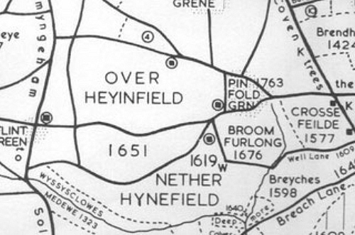
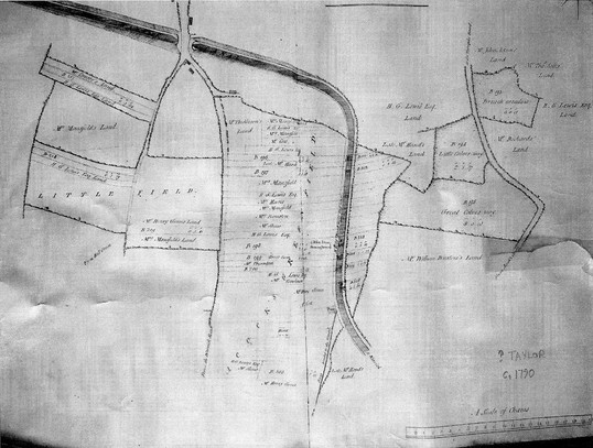
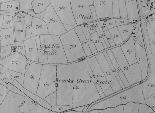
Because of what can be seen the 1843 Tithe map, it is possible to see back to the medieval period where Yardley Road is considered. The Tithe map shows remnants of an open field system, where fields were farmed in long strips in common, with the good and poor land being shared out. The boundaries of the two main fields are shown below on the extract from John Morris Jones’s map, which was reproduced in Discovering Yardley by Victor Skipp. North is to the east here, and the boundaries of the system are Stockfield Road and the Westley Brook valley. In the middle, leading from Flint Green north towards the Coventry Road, is the old ridgeway track to Yardley church from the south of Yardley manor. Yardley Road itself is seen as later, becoming worn initially as a field track. Whether it was a field boundary track is not entirely clear. For some detail about this, see our pages on Stockfield Road. The 1790 map below shows how the canal truncated the strips in Acocks Green Field (thanks to David Treadwell).
At the point where the ridgeway (Wynford Road) and Yardley Road meet, there was a green known as Pinfold Green, where the canal would later come through. It has been suggested that the earliest settlement here, associated with the open field system, was close by. It had the name of Tenelee, or Tenchlee. Three small farms are shown on the Tithe map close to here. At the junction of today’s Wynford and Yardley Roads was the Thickbroom’s farm. Mansfield Farm, just over the canal, still has some timber-framed buildings, and Fieldgate Farm east of Yardley Road and owned by William King in the 1840s, was divided by the bend in the canal. There were several buildings along the roadside, and a row of timber-framed cottages set a little back from the road. They stood until 1977, and latterly functioned as Mary’s Dog Parlour. In 1841, somewhere in Acocks Green Field, stood a house belonging to Benjamin Cook, a significant figure in the development of Acocks Green.
At enclosure, what remained of the common land was enclosed. Land was allocated to existing landowners in proportion to the land they owned elsewhere in Yardley, so the field size that resulted varied between very narrow strips and larger and broader units. These can be seen on the Enclosure and Tithe map extracts below. The owners of these can be looked up on the Tithe Apportionment. After the railway station opened for passengers in 1853, large houses began to appear nearby, occupied by men of substance and business. The first Great Western inn appeared at this time. The 1888 map shows these houses mostly occupying some of the long strips of land either side of Yardley Road.
The 1904 map and 1904 directory show Yardley Road is still residential. A few semis and terraces have been built along the road, adding to the large houses seen on the 1888 map. This is the tipping point. In a few years Yardley Road will be lined with shops, there will be a new Baptist church, and Acocks Green’s second village centre will have come into being. The last substantial changes came with the loss of all but two of the large houses between the 1930s and 1960s, and their replacement with short roads, flats and schools.


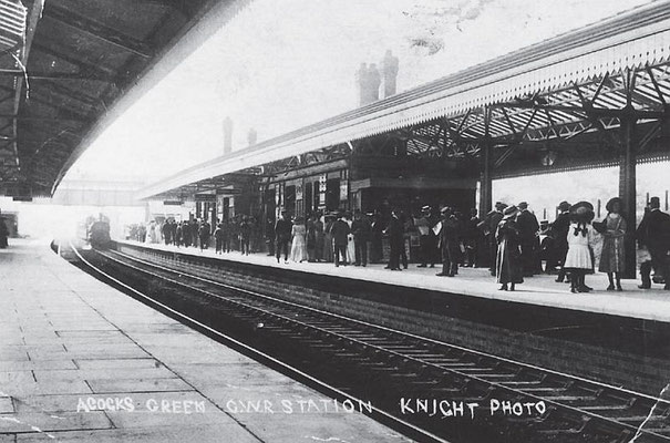
The railway station opened for passengers in 1853. See our pages on railways for more detail. Relatively late on the scene was the garage next to the railway on the odd-numbered side. This opened c. 1928 as Roberts and Co., with builders or timber merchants alongside. The police station opened formally in 1910, and included a courthouse at the rear and police houses. Numbers 25 and 27 were in the police station block. Perhaps surprisingly, they were rented out to non-police personnel. Thomas Bloye, father of the well-known Birmingham sculptor, was listed at number 25 on the 1911 census. His hardware business was on the other side of the road at number 156. Also, a John Frank Hudson was listed at number 29, but his business was at number 168. On the other side of Alexander Road, the architecturally significant Baptist church opened in 1914. For more information on this group of buildings, see this page.
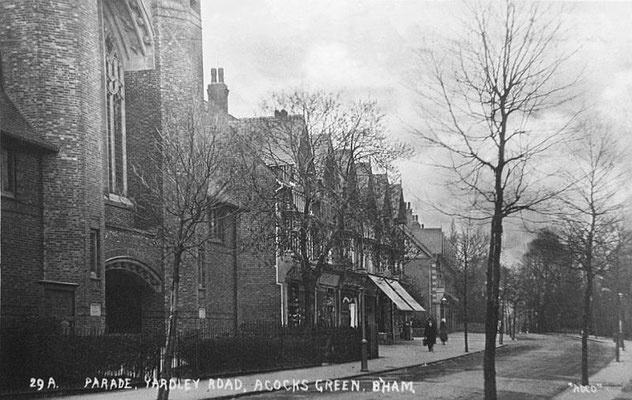
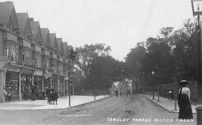
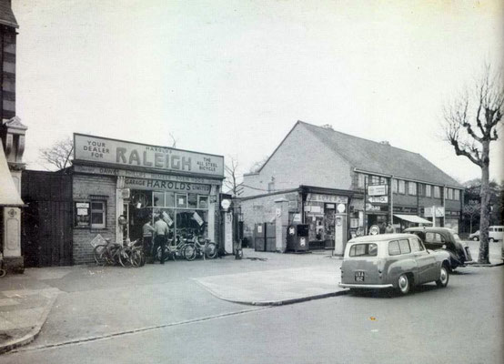
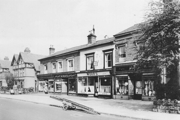
The shops from 41 to 51 appeared c. 1907, and the shops numbers 53 to 67 after Douglas Road first appear in a 1909 directory. Number 55 became a centre for the elderly and community centre about 2010. At one point, all but one of this second row were Co-op branches. Number 69 appears around 1924, as Roberts and Co, motor engineers, their earlier site on Yardley Road. This later became Harold’s Garage. Number 71, originally and still a stationer’s business around c. 1970, appeared at the same time. Of numbers 73-79 the first one was well known as the 4 o’clock Café, and an excellent book about it and Acocks Green in general was written by Frances Wilmot. The book says they moved into the premises in 1936, so that gives a date for this group of shops.
The first large house, the Beeches (later number 79), can be traced back in directories to 1868. In 1871 a grocer and tea dealer lived there. Later a retired pork butcher, a Mr Samuel Issett, was there from the end of the nineteenth century. He died in 1922. He had been a butcher on the Coventry Road in Small Heath, and was a councillor for Yardley and Birmingham, and held offices in charities as well. The Beeches was replaced by Beeches Avenue around 1935. Originally, this short road had houses on one side only, but the sale of the tennis court at the rear of number 111, Eastbourne House school, gave it a few houses on the right hand side from around 2014.
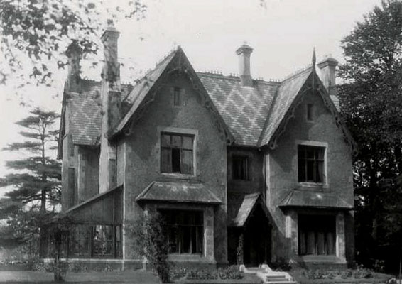
Number 111 itself, originally known as Fern Bank, dates from 1858, and still stands. The first occupant was a draper, John Barker. Later the dry cleaning family of Beckett were there. The house has a long history as a school (see also mug photo below).
Next was number 127, originally the Cedars. This goes back to at least 1868, and in 1873-4 Ebenezer Hoskins lived there. He was a bed manufacturer, better known living at the Grange in Yardley. By 1876 the Neales were there. They were well-known silversmiths and jewellers. William Neale died in 1928. In an obituary he was described as the ‘father of the Birmingham Jewellery trade’ (see below). The house was listed with two surnames in the 1939 voters list, but was not listed as occupied in the 1965 voters list.
Down a drive between here and the last large house was Sunnymount, which dates from c. 1873, and was lived in by Charles Parsons, a coffin manufacturer. Around World War One the Brownswords were living there. Frederick had been a landlord at a number of pubs. Sunnymount was eventually used by Midland Counties Dairy as a depot, then by the R.A.F. in the war, and in 1946 it collapsed after a very long period of neglect. Arthur Lockwood painted the house, and his diaries tell the story of the last years of this once important dwelling.
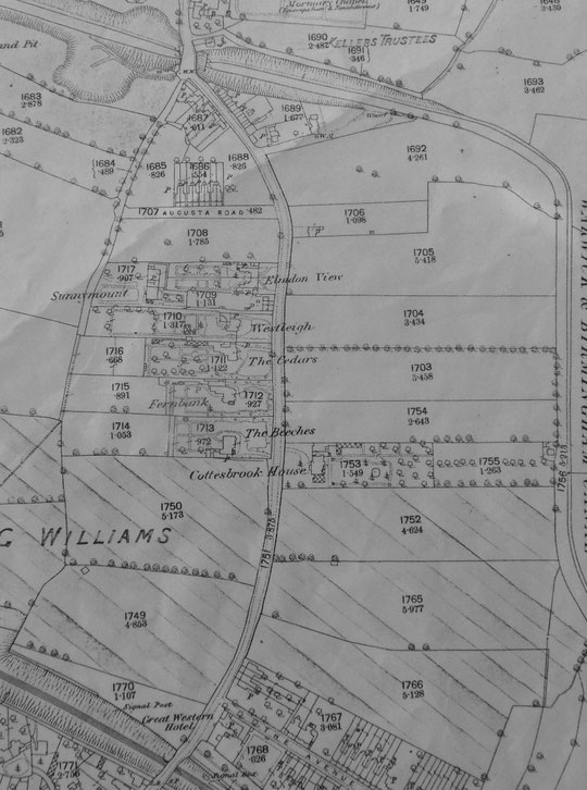
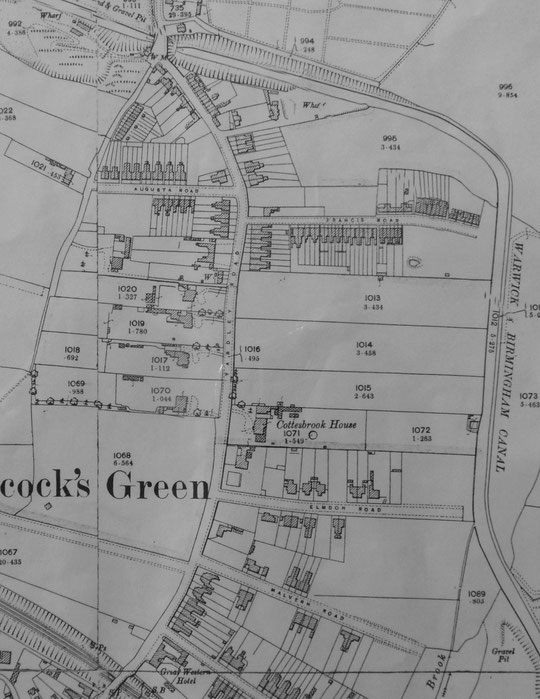
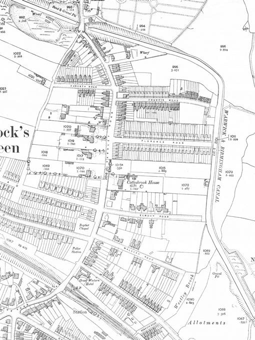
The last large house was Westleigh, or number 141, and this can be traced back to c. 1879. For about ten years from 1899 Walter Walters, a wholesale fish merchant, J.P. and councillor, lived there. In 1911 Charles Hyde lived there. He was General Manager of the B.S.A. Cycle Department at the time. In 1965 it was divided into flats, and that had probably happened after the war. It is listed in a directory of 1967-8, but was replaced by Cottesbrook Junior school in 1968, along with the Cedars. Cedars Avenue was built at the back of the former house site, where there had been tennis courts in the 1940s and 1950s.
Three very small cottages, numbers 145-9, originally known as Yew Tree Cottages, go back to at least to the 1861 census. These were probably built as farmworkers’ cottages. They were followed by two large semi-detached dwellings, numbers 151 and 153, for many years known as Elmdon Lodge 1 and 2. Number 153 was known as Jesmond Dene in 1911. This group of dwellings was replaced by Langworth Avenue c. 1972 and numbers 149-55 and number 163.
Number 165, Eagles Cliff, was listed in a directory of 1897, as was its neighbour, Ecclesbourne, number 167. Number 165 was listed as Birmingham Education Committee’s Housewifery Centre in 1930 and in 1961 as their Home Organisation centre. Perhaps this facility was provided for the families on the Stockfield estate in particular. Numbers 169-75 (San-Remo, Oak Dene, Ivanhoe and Ben Nevis) may date from a couple of years later. In 1925 and 1930 number 173 was listed as a nursing home, then in 1933 as the Ivanhoe Maternity and Nursing Home. By 1940 the Ivanhoe nursing home was on Wynford Road, in the large house at the end of Augusta Road originally called Abbotsford. After a period when it was single name residential, number 173 was divided into flats by 1965. At the end of 1989, permission was given to turn numbers 173 and 175 into a hotel.
After Augusta Road there are number 177 (One Oak, c. 1903), number 179 (One Ash, c. 1903), the detached house number 181 (Windermere, c. 1906?), 183 and 185 (Romsdal and Glenthorne c. 1907), and numbers 187 and 189 (St. Vedas and Roseleigh c. 1907). Number 177 has been associated with the name Matthieson since c. 1956. Numbers 191 and 193 are inter-war semis of c. 1931. Number 201 (Ferndale, c. 1888), numbers 203-5 (Woodbine Cottage and Oak Cottage c. 1885), 207 (Laurel Cottage c. 1887), and Olton Lodge and Sheldon Lodge (numbers 209 and 211 c. 1879) complete the additions to the corner. The family of Ernest (Chinese) Wilson, the famous plant hunter, were at number 209 from c. 1912 until the 1920s.
At the corner with Wynford Road still stands number 213, a former farmhouse, which became a branch of Painter’s funeral business around 2014. It appears to have had the name Sunnymount Lodge on the 1911 census. In any event, it functioned as a shop for some years, then a florist with one of Ernest Wilson’s sisters (May) there with her husband John Butler, then it was a builders’ business after the war. Its architecture is unusual for the area. Just before the canal, directories have shown a coal merchant, a sand merchant, and a public weighbridge. The house for this had more floors on the canal bank façade then at the Yardley Road façade. There had been a tunnel at the canal, then a bridge, which was itself replaced in 1937. For information about the canal itself, see our page.


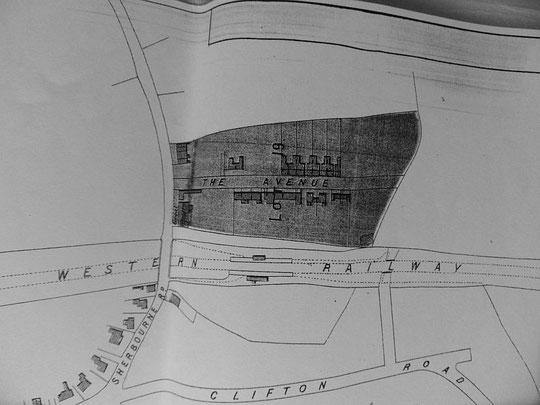
The railway station was enlarged in 1906/7 to four tracks, but reduced back to two in 1968. The canopy over the entrance was taken down. The small shops between the bridge and the Great Western appear in a directory of 1927. The Great Western itself appeared in its first version with the railway station in 1852, but it was demolished and replaced by the current building in 1956/7. In 2002 plans were approved to develop land at the rear for residential purposes. Number 12 (Strathmore) can be traced back to c. 1896, as can number 14 (Rose Villa or Roseville). Certainly number 14 once functioned as a hotel, taking overspill clients from Elmdon Lodge (thanks to Ann Clarke), but both were mentioned together as a hotel in a planning application of 1998 to convert them to flats. By 2001 the seven flats were referred to as bedsits, and in 2002 permission was granted to construct three flats in three stories behind the former hotel, i.e. on the Avenue.
The next four houses are considerably older. They appear on the Cook estate map of 1875, but ground rents go back to 1863. Number 16 was Malvern Villa 1 or Auchintore or The Ferns, and was occupied by a jeweller named Peter William Swasbrook in 1871 and 1881. Mrs Swasbrook was there in 1891. Number 18 was Malvern Villa 2 or Avonbury, and was lived in by a brassfounder named Benjamin Jackson in 1868 and 1871, and an electro-gilder named Samuel Wollaston in 1881. It was a grocery shop in 1912. Number 20, Froome Villa, was occupied by a gunmaker named George Hackett in 1868 and 1871, and a jeweller named Patterson in 1881, and was occupied by a plumber in 1912. Number 22, Keynsham Villa, was occupied by James Wheway, a manufacturing jeweller, in 1871. In 1891 a manufacturer of steel toys named George Twigg lived there. It was a confectioner’s in 1912.
The next four houses did not succumb to being turned into shops. Number 24 (Clydesdale, Innisdale, Innisfall?) and number 26, Oakfield, probably date from c.1889. Number 28, Bedale or Ambleside, and number 30, Hawthornden, date from the same time. Both the last two had professional occupants at the beginning of the 20th century. After Malvern Road stood number 44, Newstead, probably from c. 1895. Henry Allsop lived here until his death in 1917. He was a jeweller by profession. They were followed by the Dipple family, master butchers, who were there until the 1950s. Newstead was replaced by Malvern Court c. 1965.
Number 50, Elmdon Lodge, was designed by the architect John Coulson Nicol, and appeared c. 1903. He died in 1933 at Elmdon Lodge, Elmdon Road, which he also designed. In 1911 the house was called Earls Ferrie, and was occupied by Juan Bautista Zangroniz, a Cuban diplomat. In the 1920s and until 1937 a hardware merchant, Frederick Allenby, is listed there. A local campaign led by Acocks Green Focus Group to rescue it from unsympathetic alterations was successful, and it is locally listed.
After Elmdon Road stood number 70, or the Croft, c. 1890. W.P. Hoskins of the bed manufacturing company was there in 1891. From 1899 a fish merchant named Joseph Smith was there, then from c. 1908 Joseph Gloster, a silversmith and local councillor and J.P. The Croft was replaced by shops, numbers 58-68, around 1937.
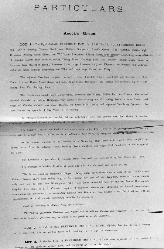
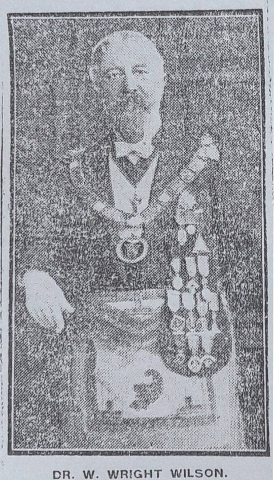
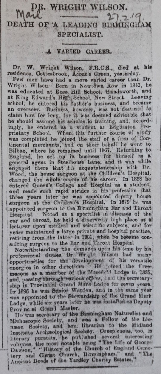
The next house, Cottesbrook House, was probably the second most spectacular house in Acocks Green after Fox Hollies Hall. It was built for Joseph Wilson, a very prominent and respected gunmaker, probably in the late 1850s. He employed the architect J. A. Chatwin, who also worked on St. Mary’s church later, to design his house. The garden near the house had a fountain, and, almost unbelievably, had a swimming pool next to the canal, using filtered canal water! How he managed to arrange this is unknown. The grounds covered three of the long and narrow fields seen on the enclosure map, and the estate was bordered with trees, which were shown on the 1888 map. The two fields north of the house and garden were described as prime building land in the estate sale in May 1893, which followed Joseph Wilson’s death. He left almost five million pounds in his will in today’s money. House and contents were put up for sale. However the house continued to be lived in by the family. One son, John Henry Wilson, who had followed his father into the gun trade, died in 1896. Two other brothers had died by 1900. The eldest son moved into Cottesbrook House. He was William Wright Wilson, who as a young man had been in the gun trade and then in business, but then became a surgeon’s assistant, and then an aural surgeon, reaching high levels in the Children’s and the Ear and Throat Hospital. He lived at the Crescent, Cambridge Street, Ladywood for some time. He married in 1873, but the couple had no children. His wife Emily died in 1902, and here the story takes an unusual turn. In June 1904, he and John Henry Wilson’s widow turn up in New York and a few days later get married there, with her nephew, a medical student, accompanying them. It was illegal to marry your brother’s widow in England until 1921, so the couple found a way to be legitimately together in God’s eyes, if not in England’s. Unfortunately, his second wife died in 1908. Her wills index entry refers to her as a widow, which was perhaps not the whole of the story. However, William Wright Wilson is then to be found in the 1911 census with another wife more than twenty years younger than him, and her mother, who was his age. They got married in Sheffield in 1909. He himself died in 1919, and several eulogies followed in the local newspapers. He was a Mason in the Alma Mater Lodge, and reached high rank in Masonic circles. His obituary is below, which shows his many interests and achievements in a wide range of fields. He had a family crest. His widow, Amy Eliza, left Cottesbrook House after a while and sold it to one Charles Alder, the grandfather of John Alder of the Alder estate in Acocks Green. The northernmost field had been sold to enable the south side of Florence Road to be built, and in 1932 part of the middle field was sold to the City to enable Cottesbrooke school to be built. In the mid-1930s Cottesbrook Road appears in the Electoral roll, but without any occupants. The houses do not seem to have been occupied until 1938. The emergency edition of the six-inch map in 1938 shows the row of shops which replaced Cottesbrook House, namely numbers 70 to 78, but directories do not show occupation until after the war. This seems unlikely.
The shops, numbers 108 to 124, appeared very briefly without business designations, but were quickly known as Market Place 1-9. They were in a directory of 1905, as were the row 126 to 142. Some of these were numbered in 1910 as Market Place 10-16. Numbers 144-160 date from c. 1890. After 1905 most became shops, while two remained residential until the 1950s, numbers 158 and 160, after which number 158 had a business. Both are residential now, and a few former shops elsewhere on this side of the road have been converted into houses. Maybe this trend will continue as local shopping centres struggle. The original house names were Fernleigh and Weardale/Glandovey. Names of the others which lasted a few years were Bella Vista, Kelpie Cottage, Vida, the Priory, Jesmond, Oakhurst, Burnside, Cumnor, Yewdale, Llanthony/Glen Clova and Tranmere. Westwater was another name for one of the houses.
After Francis Road a house was built in the early 1880s called Henley Lodge. This originally had grounds stretching back into what became Francis Road. It was some distance away from other houses when first built, so afforded the same status and seclusion as the bigger houses on the road. Joseph Gloster was there in 1891. A Methodist Minister, George Hill, was there in 1911. Henley Lodge became number 162. Later, as various businesses occupied the house and extensions were built on the front, it became 162-6. By 1930, a motor cycle agent was operating from 164 and the Mirror Laundries from 166. Smiths garage had one of their sites here.
The three houses numbers 168 to 172, date from c. 1905. and were always shops.
The next group is 174 (Clovelly), 176 (Lyndon/Lynton/Lyton Villa), 178 (Ivy Dene), 180 (The Ferns/Primrose Villa), 186 (Treflach), 188 (Trefoil), 190 and 192 (Ida-Merle), which date from c. 1890. Summerfield also makes an appearance as a name, but we cannot pin it on any one number.
A track led down to Yardley wharf after number 192. The half-timbered Fieldgate Farm was a little way down here. Tree-ring dating suggests it dated from the first half of the 17th century. The name suggests it was a way into the open field called Acocks Green Field. The farmhouse/cottages had a sad end in 1977, being taken apart and the wood being stored at the Museum, despite local protests. The fields for this farm were divided by the canal. The building was divided into three cottages, and at various times housed boot makers and repairers. In the 1960s Mary’s Dog Parlour was in business from here. Further down the lane coal suppliers were listed, which used the canal. A building by the canal is on the 1888 map. This was later the Co-op’s coal house. They started in business here around World War One. Later builders occupied the site. Other farm buildings on the Yardley Road housed a shop, Frederick Myttion’s, which survived the building of a row of terraces up to the canal in the 1880s. Later a floristry business was there. From numbers 204 to 228, 218 to 228 are still standing. Sheltered housing replaced the others and occupied land on the corner of this track around 1982. There had been a builders’ yard and concrete and brick crushing business there before then.


It is now possible to see the sequence of large-scale O.S. maps online at www.old-maps.co.uk. For this road enter the postcode B27 6LL, and choose the 1:2,500 maps up until 1952-4 (there is no 1937 map at this scale). Use the plus and minus buttons to change how close up you wish to see the houses. The map can be dragged by using click and hold as normal.
Return to AGHS Homepage